alb2602320
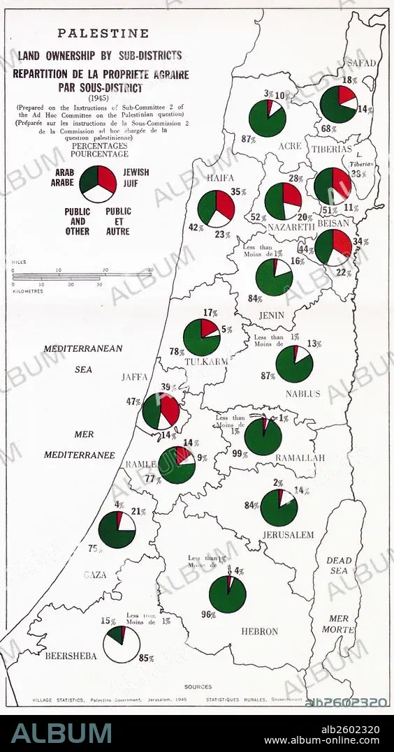
Map showing Palestine Land Ownership by Sub-District.
| Partager |
|---|
 Pinterest Pinterest |
 Twitter Twitter |
 Facebook Facebook |
 Copier le lien Copier le lien |
 Email Email |
|
Ajouter à une autre Lightbox |
|
Ajouter à une autre Lightbox |


Avez-vous déjà un compte? S'identifier
Vous n'avez pas de compte ? S'inscrire
Acheter cette image.
Sélectionnez l'usage:

Titre:
Map showing Palestine Land Ownership by Sub-District.
Légende:
Voir la traduction automatique
Map showing Palestine land ownership percentages by sub-district. Arab ownership is marked in green and Jewish ownership is makerd in red. Dated 1945.
Crédit:
Album / Universal Images Group / Universal History Archive
Autorisations:
Modèle: Non - Propriété: Non
Questions sur les droits?
Questions sur les droits?
Taille de l'image:
2808 x 5100 px | 41.0 MB
Taille d'impression:
23.8 x 43.2 cm | 9.4 x 17.0 in (300 dpi)
Mots clés:
ARABE • ARABIE • CARTE (GEOGRAPHIE) • CARTE GEOGRAPHIQUE • CARTE • DESSIN PLANS • ISRAEL • JUIF (ADJECTIF) • JUIF • JUIFS (NOM) • JUIFS • JUIVE • PALESTINE • PLAN (CARTOGRAPHIE) • PLANS • XXE SIECLE
