alb2208602
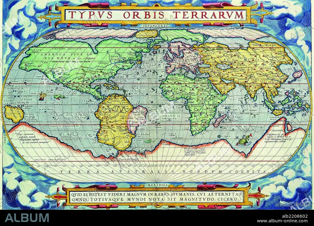
Typus Orbis Terrarum from the Theatre of the World in Apian Projection 1570
| Partager |
|---|
 Pinterest Pinterest |
 Twitter Twitter |
 Facebook Facebook |
 Copier le lien Copier le lien |
 Email Email |
|
Ajouter à une autre Lightbox |
|
Ajouter à une autre Lightbox |


Avez-vous déjà un compte? S'identifier
Vous n'avez pas de compte ? S'inscrire
Acheter cette image.
Sélectionnez l'usage:

Titre: Typus Orbis Terrarum from the Theatre of the World in Apian Projection 1570
Légende: Voir la traduction automatique
Abraham Ortelius (Abraham Ortelius) (April 14, 1527 – June 28, 1598) was a Flemish cartographer and geographer, generally recognized as the creator of the first modern atlas, the Theatrum Orbis Terrarum (Theatre of the World). He is also believed to be the first person to imagine that the continents were joined together before drifting to their present positions. In 1564 he completed a "mappemonde", eight-leaved map of the world, which afterwards appeared in reduced form in the Theatrum. The only extant copy of this great map is in the library of the University of Basel. On May 20, 1570, Gilles Coppens de Diest at Antwerp issued Ortelius’ Theatrum Orbis Terrarum, the "first modern atlas" (of 53 maps). Three Latin editions of this (besides a Dutch, a French and a German edition) appeared before the end of 1572; twenty-five editions came out before Ortelius' death in 1598; and several others were published subsequently, for the atlas continued to be in demand until about 1612
Abraham Ortelius (Abraham Ortelius) (April 14, 1527 – June 28, 1598) was a Flemish cartographer and geographer, generally recognized as the creator of the first modern atlas, the Theatrum Orbis Terrarum (Theatre of the World). He is also believed to be the first person to imagine that the continents were joined together before drifting to their present positions. In 1564 he completed a "mappemonde", eight-leaved map of the world, which afterwards appeared in reduced form in the Theatrum. The only extant copy of this great map is in the library of the University of Basel. On May 20, 1570, Gilles Coppens de Diest at Antwerp issued Ortelius’ Theatrum Orbis Terrarum, the "first modern atlas" (of 53 maps). Three Latin editions of this (besides a Dutch, a French and a German edition) appeared before the end of 1572; twenty-five editions came out before Ortelius' death in 1598; and several others were published subsequently, for the atlas continued to be in demand until about 1612
Crédit: Album / Universal Images Group / Universal History Archive/UIG
Autorisations: ? Autorisation de modèle: Non - ? Autorisation de propriété: Non
Questions sur les droits?
Questions sur les droits?
Taille de l'image: 3762 × 2508 px | 27.0 MB
Taille d'impression: 31.9 × 21.2 cm | 1481.1 × 987.4 in (300 dpi)
Mots clés: ANGLETARRE • ANGLETERE • ANGLETERRE • ANTIQUAIRE • CARTE (GEOGRAPHIE) • CARTE GEOGRAPHIQUE • CARTE • CARTOGRAPHE • CARTOGRAPHIE • DESSIN PLANS • GLOBE • GRANDE BERTAGNE • GRANDE BRETAGNE • GRANDE-BRETAGNE • HEMISPHERE (ASTRONOMIE) • INGLATERRA • LIBRAIRIE D'OCCASION • LONDRES • LONDRES, VUE SUR • LONDRES, VUE • MER • MONDE • OCEAN • PAYSAGE MARITIME • PLAN (CARTOGRAPHIE) • PLANS • PROJECTION • ROYAUME UNI • ROYAUME-UNI • SCIENCE: CARTOGRAPHIE • VUE LONDRES
