alb5471988
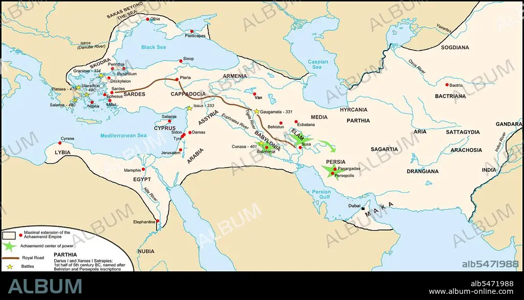
Middle East: Map of the Persian Achaemenid Empire and the section of the Royal Road noted by Herodotus c. 5th century BCE, with location of Maka, now including Dubai in the United Arab Emirates. Map by Fabienkhan (CC BY-SA 3.0 License)
| Partager |
|---|
 Pinterest Pinterest |
 Twitter Twitter |
 Facebook Facebook |
 Copier le lien Copier le lien |
 Email Email |
|
Ajouter à une autre Lightbox |
|
Ajouter à une autre Lightbox |


Avez-vous déjà un compte? S'identifier
Vous n'avez pas de compte ? S'inscrire
Acheter cette image.
Sélectionnez l'usage:

Titre: Middle East: Map of the Persian Achaemenid Empire and the section of the Royal Road noted by Herodotus c. 5th century BCE, with location of Maka, now including Dubai in the United Arab Emirates. Map by Fabienkhan (CC BY-SA 3.0 License)
Légende: Voir la traduction automatique
The Persian Royal Road was an ancient highway reorganized and rebuilt by the Persian king Darius the Great (Darius I) of the Achaemenid Empire in the 5th century BC. Darius built the road to facilitate rapid communication throughout his empire. The course of the road has been reconstructed from the writings of Herodotus, archeological research, and other historical records. It began in the west in Sardis (on the Aegean coast of Lydia, about 60 miles east of Izmir in present-day Turkey), traveled east through what is now the middle northern section of Turkey, (crossing the Halys according to Herodotus) and passed through the Cilician Gates to the old Assyrian capital Nineveh (present-day Mosul, Iraq), then turned south to Babylon (near present-day Baghdad, Iraq). From near Babylon, it is believed to have split into two routes, one traveling northeast then east through Ecbatana and on along the Silk Road, the other continuing east through the future Persian capital Susa (in present-day Iran) and then southeast to Persepolis.
The Persian Royal Road was an ancient highway reorganized and rebuilt by the Persian king Darius the Great (Darius I) of the Achaemenid Empire in the 5th century BC. Darius built the road to facilitate rapid communication throughout his empire. The course of the road has been reconstructed from the writings of Herodotus, archeological research, and other historical records. It began in the west in Sardis (on the Aegean coast of Lydia, about 60 miles east of Izmir in present-day Turkey), traveled east through what is now the middle northern section of Turkey, (crossing the Halys according to Herodotus) and passed through the Cilician Gates to the old Assyrian capital Nineveh (present-day Mosul, Iraq), then turned south to Babylon (near present-day Baghdad, Iraq). From near Babylon, it is believed to have split into two routes, one traveling northeast then east through Ecbatana and on along the Silk Road, the other continuing east through the future Persian capital Susa (in present-day Iran) and then southeast to Persepolis.
Crédit: Album / Pictures From History/Universal Images Group
Autorisations: ? Autorisation de modèle: Non - ? Autorisation de propriété: Non
Questions sur les droits?
Questions sur les droits?
Taille de l'image: 5100 × 2659 px | 38.8 MB
Taille d'impression: 43.2 × 22.5 cm | 2007.9 × 1046.9 in (300 dpi)
Mots clés: ACHEMENIDE • ANT. OR.: IRAN • ART PERSAN • ASIE • ASIE, CONTINENT • CARTE (GEOGRAPHIE) • CARTE GEOGRAPHIQUE • CARTE • CARTOGRAPHIE • COMMUNICATION • CONTINENT ASIE • DESSIN PLANS • HISOIRE • HISTOIRE • IRAN • IRAN, ANT. OR. • IRANIEN • IRANIENNE • METIER • MYTHES: PERSES • PERSAN • PERSE • PERSES • PERSES, MYTHES • PLAN (CARTOGRAPHIE) • PLANS • SCIENCE: CARTOGRAPHIE • TRANSPORT
