alb5472715
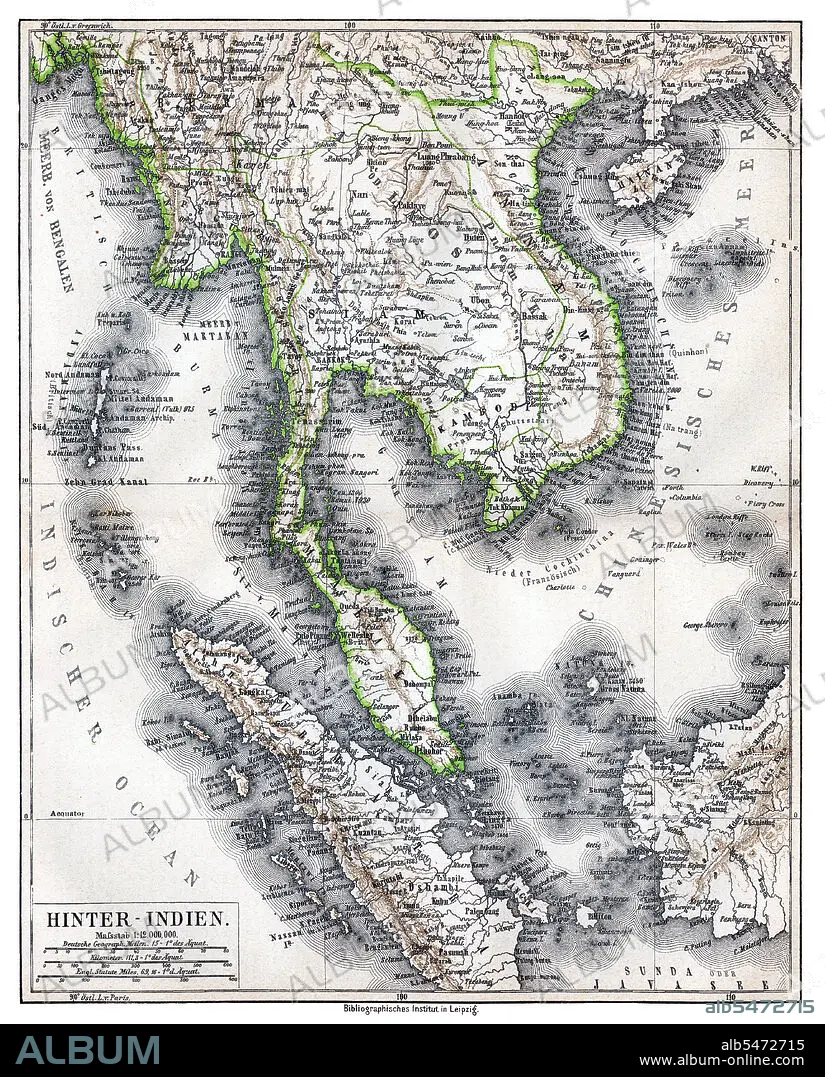
Hinter-Indien' ('Further India'), a map of Greater Indochina and the western part of the Malay-Indonesian Archipelago, Bibliographisches Institut in Leipzig, Germany,1876.
| Partager |
|---|
 Pinterest Pinterest |
 Twitter Twitter |
 Facebook Facebook |
 Copier le lien Copier le lien |
 Email Email |
|
Ajouter à une autre Lightbox |
|
Ajouter à une autre Lightbox |


Avez-vous déjà un compte? S'identifier
Vous n'avez pas de compte ? S'inscrire
Acheter cette image.
Sélectionnez l'usage:

Titre: Hinter-Indien' ('Further India'), a map of Greater Indochina and the western part of the Malay-Indonesian Archipelago, Bibliographisches Institut in Leipzig, Germany,1876.
Légende: Voir la traduction automatique
Physical map showing approximate political frontiers in Green. The Shan and Lao states are shown independent of (or tributary to) Siam. Chiang Mai ('Tshien-Mai'and Luang Prabang are both shown lying within the frontiers of a greater Siam,, but the territoryy of Chiang Mai extends further to the northwest, into Burma's Shan State, beyond the Salween River, than it does today. Cambodia is much curtailed, with Angkor and Battambang part of Siam. Champa is still indicated in southern Vietnam ('Tshampa'), though it finally ceased to exist in 1832. The Lao kingdoms of Luang Prabang, Vientiane (Vien Tscan) and Champassak are all represented as part of Greater Siam. The Anglo-French competition for dominion over the region was just starting, and over the next 30 years Siam would lose much of its territory to the east and Northeast, as well as in the Malayan Peninsula.
Physical map showing approximate political frontiers in Green. The Shan and Lao states are shown independent of (or tributary to) Siam. Chiang Mai ('Tshien-Mai'and Luang Prabang are both shown lying within the frontiers of a greater Siam,, but the territoryy of Chiang Mai extends further to the northwest, into Burma's Shan State, beyond the Salween River, than it does today. Cambodia is much curtailed, with Angkor and Battambang part of Siam. Champa is still indicated in southern Vietnam ('Tshampa'), though it finally ceased to exist in 1832. The Lao kingdoms of Luang Prabang, Vientiane (Vien Tscan) and Champassak are all represented as part of Greater Siam. The Anglo-French competition for dominion over the region was just starting, and over the next 30 years Siam would lose much of its territory to the east and Northeast, as well as in the Malayan Peninsula.
Crédit: Album / Pictures From History/Universal Images Group
Autorisations: ? Autorisation de modèle: Non - ? Autorisation de propriété: Non
Questions sur les droits?
Questions sur les droits?
Taille de l'image: 3800 × 4716 px | 51.3 MB
Taille d'impression: 32.2 × 39.9 cm | 1496.1 × 1856.7 in (300 dpi)
Mots clés: ANGLETARRE • ANGLETERE • ANGLETERRE • ASIE • ASIE, CONTINENT • CAMBODGE • CARTE (GEOGRAPHIE) • CARTE GEOGRAPHIQUE • CARTE • CARTOGRAPHIE • COLONIALISME • CONTINENT ASIE • DESSIN PLANS • GRANDE BERTAGNE • GRANDE BRETAGNE • GRANDE-BRETAGNE • IMPERIALISME • INGLATERRA • MYANMAR • PLAN (CARTOGRAPHIE) • PLANS • ROYAUME UNI • ROYAUME-UNI • SCIENCE: CARTOGRAPHIE • THAILANDE • VIETNAM
