alb15530062
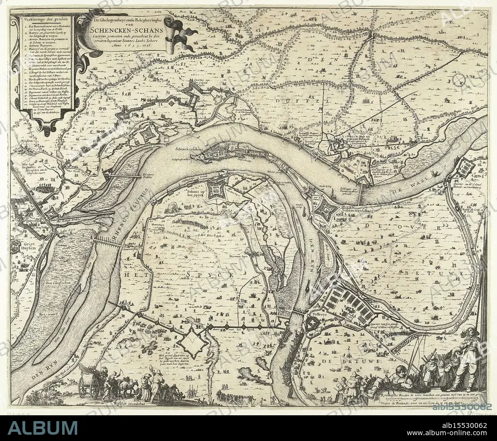
Amsterdam, Visscher, Claes Jansz. (II), Schort, Johannes Jacobus, The Siege and Besiegement of Schencken Schans Curyeus measured and drawn by the experienced Engineer Ioannes Iacobi Schort Anno 1635. and 36., Map with the siege and conquest of Schenckenschans by Frederik Hendrik, 1635-1636, Map of the siege and capture of Schenckenschans, located at the fork in the Rhine and Waal, by the States army under Frederik Hendrik, 1635-1636. Top left the title and the legend 1-25. Bottom right soldiers and a fisherman with two fishing rods and a compass. At the bottom in the foreground various figures., print, picture, map, news print, prints, pictures, Frederik Muller Historieplaten, height 473 mm, width 569 mm, Noord-Nederlands, 1586 - 1652-06-19, print maker, printmaker, 1636 - 1636, second quarter 17th century, paper, papier, etching, etchings, Nederlands, cartographer, Publication (Event), Publicatie, publisher.
| Partager |
|---|
 Pinterest Pinterest |
 Twitter Twitter |
 Facebook Facebook |
 Copier le lien Copier le lien |
 Email Email |
|
Ajouter à une autre Lightbox |
|
Ajouter à une autre Lightbox |


Avez-vous déjà un compte? S'identifier
Vous n'avez pas de compte ? S'inscrire
Acheter cette image.
Sélectionnez l'usage:

Légende: Voir la traduction automatique
Amsterdam, Visscher, Claes Jansz. (II), Schort, Johannes Jacobus, The Siege and Besiegement of Schencken Schans Curyeus measured and drawn by the experienced Engineer Ioannes Iacobi Schort Anno 1635. and 36., Map with the siege and conquest of Schenckenschans by Frederik Hendrik, 1635-1636, Map of the siege and capture of Schenckenschans, located at the fork in the Rhine and Waal, by the States army under Frederik Hendrik, 1635-1636. Top left the title and the legend 1-25. Bottom right soldiers and a fisherman with two fishing rods and a compass. At the bottom in the foreground various figures., print, picture, map, news print, prints, pictures, Frederik Muller Historieplaten, height 473 mm, width 569 mm, Noord-Nederlands, 1586 - 1652-06-19, print maker, printmaker, 1636 - 1636, second quarter 17th century, paper, papier, etching, etchings, Nederlands, cartographer, Publication (Event), Publicatie, publisher
Amsterdam, Visscher, Claes Jansz. (II), Schort, Johannes Jacobus, The Siege and Besiegement of Schencken Schans Curyeus measured and drawn by the experienced Engineer Ioannes Iacobi Schort Anno 1635. and 36., Map with the siege and conquest of Schenckenschans by Frederik Hendrik, 1635-1636, Map of the siege and capture of Schenckenschans, located at the fork in the Rhine and Waal, by the States army under Frederik Hendrik, 1635-1636. Top left the title and the legend 1-25. Bottom right soldiers and a fisherman with two fishing rods and a compass. At the bottom in the foreground various figures., print, picture, map, news print, prints, pictures, Frederik Muller Historieplaten, height 473 mm, width 569 mm, Noord-Nederlands, 1586 - 1652-06-19, print maker, printmaker, 1636 - 1636, second quarter 17th century, paper, papier, etching, etchings, Nederlands, cartographer, Publication (Event), Publicatie, publisher
Crédit: Album / quintlox
Autorisations: ? Autorisation de modèle: Non - ? Autorisation de propriété: Non
Questions sur les droits?
Questions sur les droits?
Taille de l'image: 5573 × 4658 px | 74.3 MB
Taille d'impression: 47.2 × 39.4 cm | 2194.1 × 1833.9 in (300 dpi)
Mots clés: AMSTERDAM • CADRE • CAPTURE • CARTE (GEOGRAPHIE) • CARTE GEOGRAPHIQUE • CARTE • CARTOGRAPHE • CONQUETE • DESSIN PLANS • EMPREINTE • ÉVÉNEMENT • IMAGES • INTERIEUR: TABLEAUX • PAPIER • PECHEUR • PEINDRE • PEINTURE, SCENES D'INTERIE • PLAN (CARTOGRAPHIE) • PLANS • SUCCÈS • TABLEAU: SCENES D'INTERIEU • TABLEAUX • TRIOMPHE • VICTOIRE (ALLEGORIE) • VICTOIRE • VICTOIRES
