alb1962979
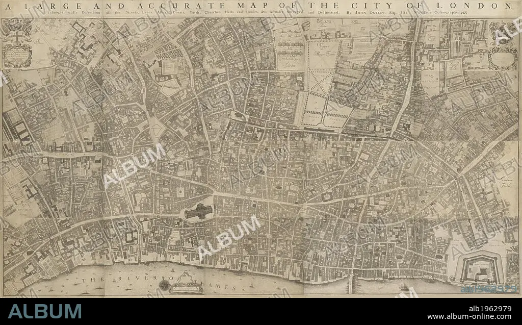
WILLIAM MORGAN et JOHN OGILBY. A large and accurate map of the City of London. Ichnographically describing all the Streets, Lanes, Alleys, Courts, Yards, Churches, Halls and Houses, &c. The city arms and dedication to the Lord Mayor, the Aldermen and Sheriffs of the city in cartouche at top left and arms of Sheldon, Lord Mayor at top right and with compass star and dividers at bottom centre. This is the first accurate and detailed map of London, with all the buildings represented in plan rather than as bird's eye views . 1677. Source: Maps.Crace.2.61.
| Partager |
|---|
 Pinterest Pinterest |
 Twitter Twitter |
 Facebook Facebook |
 Copier le lien Copier le lien |
 Email Email |
|
Ajouter à une autre Lightbox |
|
Ajouter à une autre Lightbox |


Avez-vous déjà un compte? S'identifier
Vous n'avez pas de compte ? S'inscrire
Acheter cette image.
Sélectionnez l'usage:

Légende: Voir la traduction automatique
A large and accurate map of the City of London. Ichnographically describing all the Streets, Lanes, Alleys, Courts, Yards, Churches, Halls and Houses, &c. The city arms and dedication to the Lord Mayor, the Aldermen and Sheriffs of the city in cartouche at top left and arms of Sheldon, Lord Mayor at top right and with compass star and dividers at bottom centre. This is the first accurate and detailed map of London, with all the buildings represented in plan rather than as bird's eye views . 1677. Source: Maps.Crace.2.61.
A large and accurate map of the City of London. Ichnographically describing all the Streets, Lanes, Alleys, Courts, Yards, Churches, Halls and Houses, &c. The city arms and dedication to the Lord Mayor, the Aldermen and Sheriffs of the city in cartouche at top left and arms of Sheldon, Lord Mayor at top right and with compass star and dividers at bottom centre. This is the first accurate and detailed map of London, with all the buildings represented in plan rather than as bird's eye views . 1677. Source: Maps.Crace.2.61.
Crédit: Album / British Library
Autorisations: ? Autorisation de modèle: Non - ? Autorisation de propriété: Non
Questions sur les droits?
Questions sur les droits?
Taille de l'image: 10000 × 5701 px | 163.1 MB
Taille d'impression: 84.7 × 48.3 cm | 3937.0 × 2244.5 in (300 dpi)
Mots clés: 17E SIECLE • 17EME S • ANGLETARRE • ANGLETERE • ANGLETERRE • CARTE (GEOGRAPHIE) • CARTE GEOGRAPHIQUE • CARTE • CARTOGRAPHIE • DESSIN PLANS • DIX-SEPTIÈME SIÈCLE • FLEUVE TAMISE • FRAVURE • GRANDE BERTAGNE • GRANDE BRETAGNE • GRANDE-BRETAGNE • GRAVURE • INGLATERRA • LONDRES • LONDRES, VUE SUR • LONDRES, VUE • MORGAN, WILLIAM • OGILBY, JOHN • PLAN (CARTOGRAPHIE) • PLANS • ROYAUME UNI • ROYAUME-UNI • SCIENCE: CARTOGRAPHIE • TAMISE • TAMISE, FLEUVE • VUE LONDRES • XVIIE SIECLE
