alb5407343
Petrus Apianus, World Map
| Partager |
|---|
 Pinterest Pinterest |
 Twitter Twitter |
 Facebook Facebook |
 Copier le lien Copier le lien |
 Email Email |
|
Ajouter à une autre Lightbox |
|
Ajouter à une autre Lightbox |


Avez-vous déjà un compte? S'identifier
Vous n'avez pas de compte ? S'inscrire
Acheter cette image.
Sélectionnez l'usage:

Titre: Petrus Apianus, World Map
Légende: Voir la traduction automatique
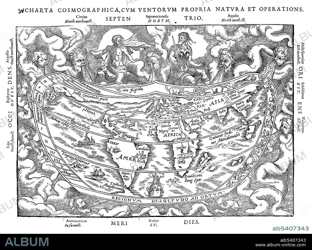
Apianus world map is from undated edition of Cosmographia. Mythical figures representing the winds and twelve compass points adorn the borders. The equator and tropics are marked. South America had been discovered by Europeans at this time, but North America is largely unmapped, as is the Far East and Australia. Petrus Apianus (April 16, 1495 - April 21, 1552) was a German humanist, known for his works in mathematics, astronomy and cartography. In 1524 he produced his Cosmographicus liber, a respected work on astronomy and navigation that was to see at least 30 reprints in 14 languages. In 1527 he published a variation of Pascal's triangle, and in 1534 a table of sines. In 1531, he observed a comet and discovered that a comet's tail always point away from the sun. In 1540, he printed the Astronomicum Caesareum, dedicated to Charles V who appointed him his court mathematician. He designed sundials, published manuals for astronomical instruments and crafted volvelles (Apian wheels), measuring instruments useful for calculating time and distance for astronomical and astrological applications. He died in 1552 at the age of 57.
Apianus world map is from undated edition of Cosmographia. Mythical figures representing the winds and twelve compass points adorn the borders. The equator and tropics are marked. South America had been discovered by Europeans at this time, but North America is largely unmapped, as is the Far East and Australia. Petrus Apianus (April 16, 1495 - April 21, 1552) was a German humanist, known for his works in mathematics, astronomy and cartography. In 1524 he produced his Cosmographicus liber, a respected work on astronomy and navigation that was to see at least 30 reprints in 14 languages. In 1527 he published a variation of Pascal's triangle, and in 1534 a table of sines. In 1531, he observed a comet and discovered that a comet's tail always point away from the sun. In 1540, he printed the Astronomicum Caesareum, dedicated to Charles V who appointed him his court mathematician. He designed sundials, published manuals for astronomical instruments and crafted volvelles (Apian wheels), measuring instruments useful for calculating time and distance for astronomical and astrological applications. He died in 1552 at the age of 57.
Crédit: Album / Science Source
Autorisations: ? Autorisation de modèle: Non - ? Autorisation de propriété: Non
Questions sur les droits?
Questions sur les droits?
Taille de l'image: 4350 × 3254 px | 40.5 MB
Taille d'impression: 36.8 × 27.6 cm | 1712.6 × 1281.1 in (300 dpi)
Mots clés: 16E SIECLE • 16EME S • ALLEMAND • ALLEMANDE • CARTE • CARTOGRAPHIE • CÉLÈBRE • CELEBRITE • MAPPEMONDE • PLANISPHERE • SCIENCE: CARTOGRAPHIE • SEIZIÈME SIÈCLE • XVIE SIECLE
