alb4475004
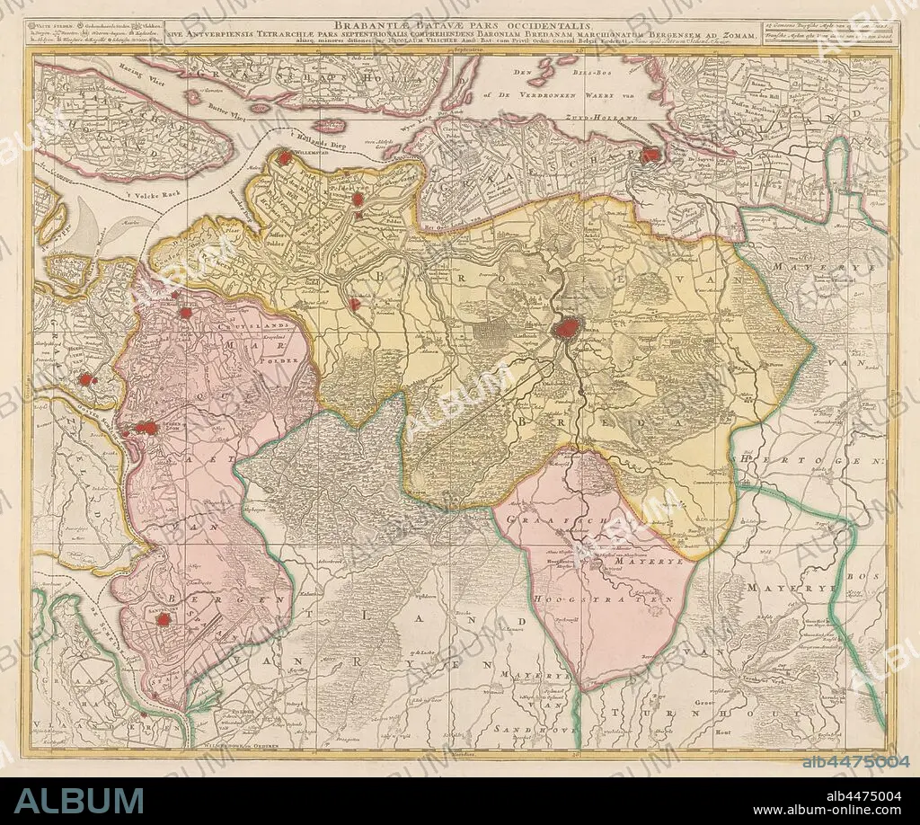
Map of the Baronie van Breda, Brabantiae Batavae pars occidentalis, sive Antverpiensis tetrarchiae pars septentrionalis: comprehendens Baroniam Bredanam, Marchionatum Bergensem ad Zomam (title on object), Map of the barony of Breda and immediate surroundings. Top left legend of cities and towns. Top right the scale in German and French miles, maps of separate countries or regions, Brabant, Breda, Nicolaes Visscher (I), Amsterdam, c. 1680 and/or c. 1780, paper, watercolor (paint), engraving, h 48.8 cm × w 57.9 cm.
| Partager |
|---|
 Pinterest Pinterest |
 Twitter Twitter |
 Facebook Facebook |
 Copier le lien Copier le lien |
 Email Email |
|
Ajouter à une autre Lightbox |
|
Ajouter à une autre Lightbox |


Avez-vous déjà un compte? S'identifier
Vous n'avez pas de compte ? S'inscrire
Acheter cette image

Légende:
Voir la traduction automatique
Map of the Baronie van Breda, Brabantiae Batavae pars occidentalis, sive Antverpiensis tetrarchiae pars septentrionalis: comprehendens Baroniam Bredanam, Marchionatum Bergensem ad Zomam (title on object), Map of the barony of Breda and immediate surroundings. Top left legend of cities and towns. Top right the scale in German and French miles, maps of separate countries or regions, Brabant, Breda, Nicolaes Visscher (I), Amsterdam, c. 1680 and/or c. 1780, paper, watercolor (paint), engraving, h 48.8 cm × w 57.9 cm
Crédit:
Album / quintlox
Autorisations:
Modèle: Non - Propriété: Non
Questions sur les droits?
Questions sur les droits?
Taille de l'image:
5687 x 4805 px | 78.2 MB
Taille d'impression:
48.1 x 40.7 cm | 19.0 x 16.0 in (300 dpi)
Mots clés:
ALLEMAND • ALLEMANDE • AMSTERDAM • AQUARELLE • BREDA • CARTE (GEOGRAPHIE) • CARTE GEOGRAPHIQUE • CARTE • CITE • DESSIN PLANS • FRAVURE • GRAVURE • OBJET • PAPIER • PEINTURE AQUARELLE • PLAN (CARTOGRAPHIE) • PLANS • REGIONS • TECHNIQUE: AQUARELLE • VILE • VILLE
