alb3837077
Mt. Hood and Columbia River Gorge, Oregon
| Partager |
|---|
 Pinterest Pinterest |
 Twitter Twitter |
 Facebook Facebook |
 Copier le lien Copier le lien |
 Email Email |
|
Ajouter à une autre Lightbox |
|
Ajouter à une autre Lightbox |


Avez-vous déjà un compte? S'identifier
Vous n'avez pas de compte ? S'inscrire
Acheter cette image.
Sélectionnez l'usage:

Titre: Mt. Hood and Columbia River Gorge, Oregon
Légende: Voir la traduction automatique
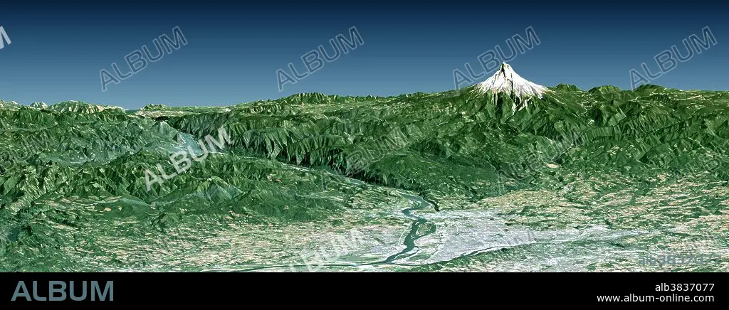
Portland, the largest city in Oregon, is located on the Columbia River at the northern end of the Willamette Valley. On clear days, Mount Hood highlights the Cascade Mountains backdrop to the east. The Columbia is the largest river in the American Northwest and is navigable up to and well beyond Portland. It is also the only river to fully cross the Cascade Range, and has carved the Columbia River Gorge, which is seen in the left-central part of this view. A series of dams along the river, at topographically favorable sites, provide substantial hydroelectric power to the region.....This perspective view was generated using topographic data from the Shuttle Radar Topography Mission (SRTM), a Landsat satellite image, and a false sky. Topographic expression is vertically exaggerated two times.....Landsat has been providing visible and infrared views of the Earth since 1972. SRTM elevation data substantially help in analyzing Landsat images by revealing the third dimension of Earth's surface, topographic height. The Landsat archive is managed by the U.S. Geological Survey's Eros Data Center (USGS EDC).....Elevation data used in this image were acquired by the Shuttle Radar Topography Mission (SRTM) aboard the Space Shuttle Endeavour, launched on February 11, 2000.
Portland, the largest city in Oregon, is located on the Columbia River at the northern end of the Willamette Valley. On clear days, Mount Hood highlights the Cascade Mountains backdrop to the east. The Columbia is the largest river in the American Northwest and is navigable up to and well beyond Portland. It is also the only river to fully cross the Cascade Range, and has carved the Columbia River Gorge, which is seen in the left-central part of this view. A series of dams along the river, at topographically favorable sites, provide substantial hydroelectric power to the region.....This perspective view was generated using topographic data from the Shuttle Radar Topography Mission (SRTM), a Landsat satellite image, and a false sky. Topographic expression is vertically exaggerated two times.....Landsat has been providing visible and infrared views of the Earth since 1972. SRTM elevation data substantially help in analyzing Landsat images by revealing the third dimension of Earth's surface, topographic height. The Landsat archive is managed by the U.S. Geological Survey's Eros Data Center (USGS EDC).....Elevation data used in this image were acquired by the Shuttle Radar Topography Mission (SRTM) aboard the Space Shuttle Endeavour, launched on February 11, 2000.
Crédit: Album / Science Source / NASA/JPL/NIMA
Autorisations: ? Autorisation de modèle: Non - ? Autorisation de propriété: Non
Questions sur les droits?
Questions sur les droits?
Taille de l'image: 2650 × 990 px | 7.5 MB
Taille d'impression: 22.4 × 8.4 cm | 1043.3 × 389.8 in (300 dpi)
Mots clés: AÉRIEN • GEOGRAPHIE • GEOLOGIE • PAYSAGE • TOPOGRAPHIE • VALLEE • VUE VILLES
