alb4859782
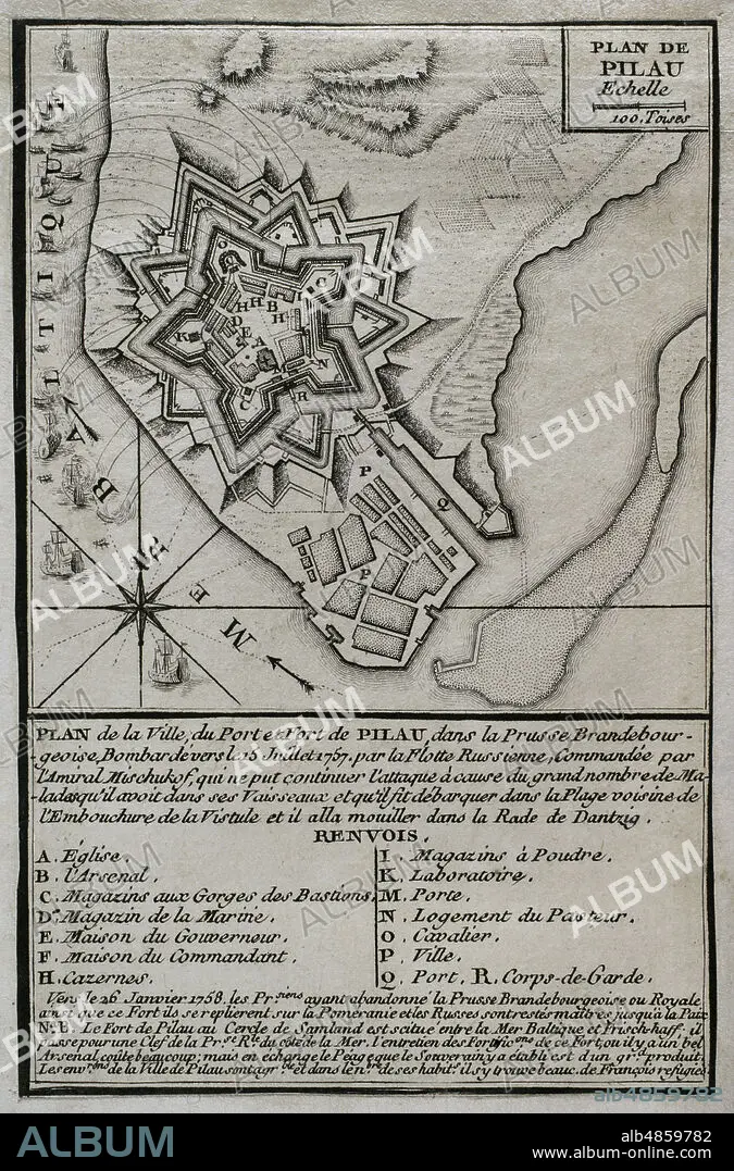
JEAN DE BEAURAIN (1696-1771). FRENCH GEOGRAPHER.. Seven Years War (1756-1763). Map of the fortress of Pillau, on the Baltic Sea. The Russian army was bombarding the fortress during 1757 and 1758, altough was forced to cease it attacks because of an excessive incidence of disease. Despite this, the Prussians abandoned the fortress in early 1758, and remained in Russian hands during the duration of the war. Published in 1765 by the cartographer Jean de Beaurain (1696-1771) as an illustration of his Great Map of Germany, with the events that took place during the Seven Years War. Engraving. French edition, 1765. Military Historical Library of Barcelona (Biblioteca Histórico Militar de Barcelona). Catalonia. Spain.
| Partager |
|---|
 Pinterest Pinterest |
 Twitter Twitter |
 Facebook Facebook |
 Copier le lien Copier le lien |
 Email Email |
|
Ajouter à une autre Lightbox |
|
Ajouter à une autre Lightbox |


Avez-vous déjà un compte? S'identifier
Vous n'avez pas de compte ? S'inscrire
Acheter cette image.
Sélectionnez l'usage:

Légende: Voir la traduction automatique
Seven Years War (1756-1763). Map of the fortress of Pillau, on the Baltic Sea. The Russian army was bombarding the fortress during 1757 and 1758, altough was forced to cease it attacks because of an excessive incidence of disease. Despite this, the Prussians abandoned the fortress in early 1758, and remained in Russian hands during the duration of the war. Published in 1765 by the cartographer Jean de Beaurain (1696-1771) as an illustration of his Great Map of Germany, with the events that took place during the Seven Years War. Engraving. French edition, 1765. Military Historical Library of Barcelona (Biblioteca Histórico Militar de Barcelona). Catalonia. Spain.
Seven Years War (1756-1763). Map of the fortress of Pillau, on the Baltic Sea. The Russian army was bombarding the fortress during 1757 and 1758, altough was forced to cease it attacks because of an excessive incidence of disease. Despite this, the Prussians abandoned the fortress in early 1758, and remained in Russian hands during the duration of the war. Published in 1765 by the cartographer Jean de Beaurain (1696-1771) as an illustration of his Great Map of Germany, with the events that took place during the Seven Years War. Engraving. French edition, 1765. Military Historical Library of Barcelona (Biblioteca Histórico Militar de Barcelona). Catalonia. Spain.
Emplacement: Historical Military Library of Barcelona. Catalonia. Spain.
Crédit: Album / Prisma
Autorisations: ? Autorisation de modèle: Non - ? Autorisation de propriété: Non
Questions sur les droits?
Questions sur les droits?
Taille de l'image: 3307 × 5018 px | 47.5 MB
Taille d'impression: 28.0 × 42.5 cm | 1302.0 × 1975.6 in (300 dpi)
Mots clés: 18 18E 18EME XVIII XVIIIE XVIIIEME SIECLE • 18E SIECLE • 18EME S • ARCHITECTURE, MILITAIRE • BALTISK • BOMBARDE • BOMBARDEMENT • BOMBARDEMENTS • CARTE (GEOGRAPHIE) • CARTE GEOGRAPHIQUE • CARTE • CARTOGRAPHIE • DESSIN PLANS • DIX-HUITIÈME SIÈCLE • EUROPE • FRAVURE • GRAVURE • GUERRE DE SEPT ANS • GUERRE • HISOIRE • HISTOIRE PRUSSE • HISTOIRE RUSSIE • HISTOIRE • HISTORICAL MILITARY LIBRARY OF BARCELONA. CATALONIA. SPAIN. • JEAN DE BEAURAIN (1696-1771). FRENCH GEOGRAPHER. • PILONNAGE • PLAN (CARTOGRAPHIE) • PLANS • PRUSSE, HISTOIRE • ROSE DES VENTS • RUSSE • RUSSIE • RUSSIE, HISTOIRE • SCIENCE: CARTOGRAPHIE • XVIIIE SIECLE
