alb4859079
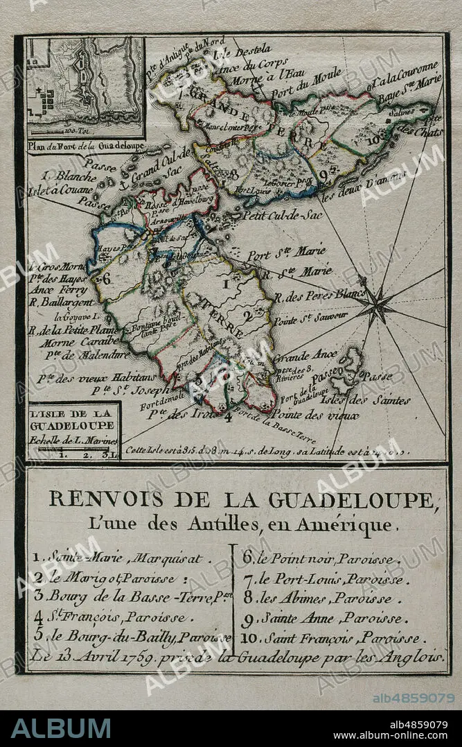
JEAN DE BEAURAIN (1696-1771). FRENCH GEOGRAPHER.. Map of Guadeloupe, 1759. Antilles Archipelago, Caribbean Sea. France took possession of the island on 28 June 1635, after landing at Pointe Allegre. During the Seven Years War, was conquered by England, founding the Port of Pointe-a-Pitre. Taking of the island of Guadeloupe by the British troops on April 13, 1759. Engraving published in 1765 by the cartographer Jean de Beaurain (1696-1771) as an illustration of his Great Map of Germany, with the events that took place during the Seven Years War. French edition, 1765. Military Historical Library of Barcelona (Biblioteca Histórico Militar de Barcelona). Catalonia. Spain.
| Partager |
|---|
 Pinterest Pinterest |
 Twitter Twitter |
 Facebook Facebook |
 Copier le lien Copier le lien |
 Email Email |
|
Ajouter à une autre Lightbox |
|
Ajouter à une autre Lightbox |


Avez-vous déjà un compte? S'identifier
Vous n'avez pas de compte ? S'inscrire
Acheter cette image.
Sélectionnez l'usage:

Légende: Voir la traduction automatique
Map of Guadeloupe, 1759. Antilles Archipelago, Caribbean Sea. France took possession of the island on 28 June 1635, after landing at Pointe Allegre. During the Seven Years War, was conquered by England, founding the Port of Pointe-a-Pitre. Taking of the island of Guadeloupe by the British troops on April 13, 1759. Engraving published in 1765 by the cartographer Jean de Beaurain (1696-1771) as an illustration of his Great Map of Germany, with the events that took place during the Seven Years War. French edition, 1765. Military Historical Library of Barcelona (Biblioteca Histórico Militar de Barcelona). Catalonia. Spain.
Map of Guadeloupe, 1759. Antilles Archipelago, Caribbean Sea. France took possession of the island on 28 June 1635, after landing at Pointe Allegre. During the Seven Years War, was conquered by England, founding the Port of Pointe-a-Pitre. Taking of the island of Guadeloupe by the British troops on April 13, 1759. Engraving published in 1765 by the cartographer Jean de Beaurain (1696-1771) as an illustration of his Great Map of Germany, with the events that took place during the Seven Years War. French edition, 1765. Military Historical Library of Barcelona (Biblioteca Histórico Militar de Barcelona). Catalonia. Spain.
Emplacement: Historical Military Library of Barcelona. Catalonia. Spain.
Crédit: Album / Prisma
Autorisations: ? Autorisation de modèle: Non - ? Autorisation de propriété: Non
Questions sur les droits?
Questions sur les droits?
Taille de l'image: 3248 × 4990 px | 46.4 MB
Taille d'impression: 27.5 × 42.2 cm | 1278.7 × 1964.6 in (300 dpi)
Mots clés: 18 18E 18EME XVIII XVIIIE XVIIIEME SIECLE • 18E SIECLE • 18EME S • AMERIQUE • AMERIQUE, CONTINENT • ANGALIS • ANGLAIS • ANGLAISE • ANGLETARRE • ANGLETERE • ANGLETERRE • ANGLETERRE, HISTOIRE • ARMEE, BRITANNIQUE • AVRIL • CARAIBE • CARAIBES • CARTE (GEOGRAPHIE) • CARTE GEOGRAPHIQUE • CARTE • CARTOGRAPHIE • COLONIALISME • CONFISCATION • CONFLICTS • CONFLIT • CONQUETE • CONTINENT AMERIQUE • DESSIN PLANS • DIX-HUITIÈME SIÈCLE • FANCE • FRANCE • FRANCE, HISTOIRE • FRANÇAISE • FRAVURE • GRANDE BERTAGNE • GRANDE BRETAGNE • GRANDE-BRETAGNE • GRAVURE • GUADELOUPE • GUERRE COLONIALE • GUERRE DE SEPT ANS • GUERRE • HISOIRE • HISTOIRE ANGLETERRE • HISTOIRE FRANCE • HISTOIRE • HISTORICAL MILITARY LIBRARY OF BARCELONA. CATALONIA. SPAIN. • ILE • ÎLES • INGLATERRA • INVASION MILITAIRE • INVASION • JEAN DE BEAURAIN (1696-1771). FRENCH GEOGRAPHER. • MER DES CARAIBES • PLAN (CARTOGRAPHIE) • PLANS • POINT-À-PITRE • POINTE-A-PITRE • REQUISITION • ROSE DES VENTS • ROYAUME UNI • ROYAUME-UNI • SAISIE • SCIENCE: CARTOGRAPHIE • SUCCÈS • TREIZE • TRIOMPHE • VICTOIRE (ALLEGORIE) • VICTOIRE • VICTOIRES • XVIIIE SIECLE
