alb11639028
Arctic ice minimum extent, 2024
| Partager |
|---|
 Pinterest Pinterest |
 Twitter Twitter |
 Facebook Facebook |
 Copier le lien Copier le lien |
 Email Email |
|
Ajouter à une autre Lightbox |
|
Ajouter à une autre Lightbox |


Avez-vous déjà un compte? S'identifier
Vous n'avez pas de compte ? S'inscrire
Acheter cette image.
Sélectionnez l'usage:

Titre:
Arctic ice minimum extent, 2024
Légende:
Voir la traduction automatique
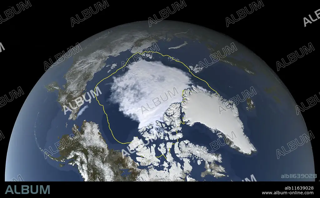
Satellite image showing the Arctic polar ice cap at its annual minimum extent on 11th September 2024. The Arctic sea ice (white, centre) reaches a minimum in September, at the end of the Arctic summer. This minimal ice area is called the perennial ice cover. The perennial ice has been steadily decreasing since satellites began observing it in 1979, at a rate of about 10 percent per decade. The yellow boundary shows the minimum extent averaged over the 30-year period from 1981 to 2010. The 2024 sea ice covers 4.28 million square kilometres and is the 7th lowest sea ice extent since records began. The decrease in perennial ice cover is attributed to climate change. Data from the Japan Aerospace Exploration Agency's Advanced Microwave Scanning Radiometer 2 (AMSR2) instrument aboard the Global Change Observation Mission 1st-Water (GCOM-W1).
Crédit:
Album / NASA's Scientific Visualization Studio/SCIENCE PHOTO LIBRARY
Autorisations:
Modèle: Non - Propriété: Non
Questions sur les droits?
Questions sur les droits?
Taille de l'image:
3941 x 2240 px | 25.3 MB
Taille d'impression:
33.4 x 19.0 cm | 13.1 x 7.5 in (300 dpi)
Mots clés:
21E SIECLE • ANNULATION • COSMOS • EAU GLACE • GEL • GEOGRAPHIE • GLACE • GLACE, EAU A L'ETAT SOLIDE • MER • MISSION • OCEAN • PAYSAGE MARITIME • PERTE • REFUS • REPONSE NEGATIVE • SATELLITE • SEPTEMBRE • TERROIR • XXIE SIECLE
