alb3907898
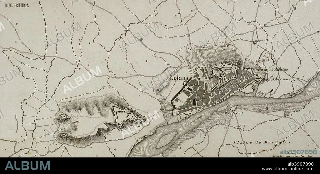
Napoleonic map. City of Lleida (Catalonia, Spain). During The Peninsular War (Napoleonic Wars) the city of Lerida was besieged on 13 May, 1810 by the French army. French victory. Atlas de l'Histoire du Consulat et de l'Empire. History of the Consulate and the Empire of France under Napoleon by Marie Joseph Louis Adolphe Thiers (1797-1877). Drawings by Dufour, engravings by Dyonnet. Edited in Paris, 1864.
| Partager |
|---|
 Pinterest Pinterest |
 Twitter Twitter |
 Facebook Facebook |
 Copier le lien Copier le lien |
 Email Email |
|
Ajouter à une autre Lightbox |
|
Ajouter à une autre Lightbox |


Avez-vous déjà un compte? S'identifier
Vous n'avez pas de compte ? S'inscrire
Acheter cette image.
Sélectionnez l'usage:

Légende:
Voir la traduction automatique
Napoleonic map. City of Lleida (Catalonia, Spain). During The Peninsular War (Napoleonic Wars) the city of Lerida was besieged on 13 May, 1810 by the French army. French victory. Atlas de l'Histoire du Consulat et de l'Empire. History of the Consulate and the Empire of France under Napoleon by Marie Joseph Louis Adolphe Thiers (1797-1877). Drawings by Dufour, engravings by Dyonnet. Edited in Paris, 1864.
Personnalités:
Crédit:
Album / Prisma
Autorisations:
Modèle: Non - Propriété: Non
Questions sur les droits?
Questions sur les droits?
Taille de l'image:
4961 x 2443 px | 34.7 MB
Taille d'impression:
42.0 x 20.7 cm | 16.5 x 8.1 in (300 dpi)
Mots clés:
ANCIEN • ANTIQUE • AUTEUR • AUTEURS • CAMPAGNES NAPOLEONIENNES • CARTE (GEOGRAPHIE) • CARTE GEOGRAPHIQUE • CARTE • CARTOGRAPHIE • CATALAN • CATALOGNE • DESSIN PLANS • DESSIN • DESSINER • ESPAGNE • ESPAGNOL • EUROPE • EUROPÉEN • FANCE • FLUVIALE • FRANCE • FRANÇAISE • FRAVURE • GEOGRAPHIE • GRAVURE • GUERRE D'INDEPENDANCE ESPAGNOLE • GUERRE NAPOLEONIENNES • GUERRE SIEGE • GUERRES NAPOLEONIENNES • HISOIRE • HISTOIRE • ILLUSTRATION • MOTIF • NAPOLÉON IER • NAPOLEON, GUERRES • PLAN (CARTOGRAPHIE) • PLANS • SCIENCE: CARTOGRAPHIE • SIEGE (GUERRE) • SIEGE (MILITAIRE) • SIEGE • TECHNIQUE: DESSIN • TERRITOIRE • THIERS • XIXE SIÈCLE
