alb9344205
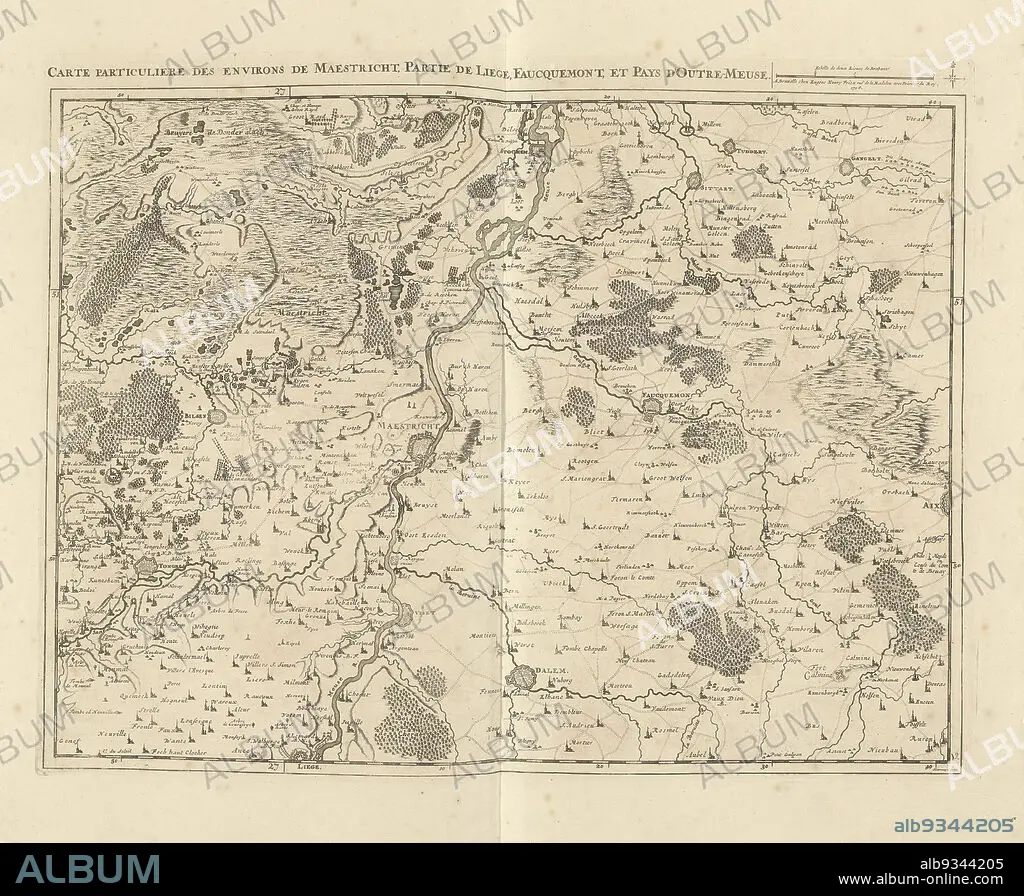
Map of Limburg with the area around Maastricht, 1708, Carte particuliere des environs de Maestricht, partie de Liege, Faucquemont, et Pays d'Outre-Meuse (title on object), Map of Limburg with the area around Maastricht, part of Liege and Valkenburg, 1708. Top right a scale bar: Echelle de deux Lieues de Brabant. The map is provided with a degree division along the edges. Part of a bundled collection of plans of battles and cities renowned in the War of the Spanish Succession. This plate is among the first 24 plates that make up a very large map of the Southern Netherlands., print maker: Jacobus Harrewijn (mentioned on object), publisher: Eugene Henry Fricx (mentioned on object), Brussels, 1708, paper, etching, engraving, height 435 mm × width 560 mm.
| Partager |
|---|
 Pinterest Pinterest |
 Twitter Twitter |
 Facebook Facebook |
 Copier le lien Copier le lien |
 Email Email |
|
Ajouter à une autre Lightbox |
|
Ajouter à une autre Lightbox |


Avez-vous déjà un compte? S'identifier
Vous n'avez pas de compte ? S'inscrire
Acheter cette image.
Sélectionnez l'usage:

Légende:
Voir la traduction automatique
Map of Limburg with the area around Maastricht, 1708, Carte particuliere des environs de Maestricht, partie de Liege, Faucquemont, et Pays d'Outre-Meuse (title on object), Map of Limburg with the area around Maastricht, part of Liege and Valkenburg, 1708. Top right a scale bar: Echelle de deux Lieues de Brabant. The map is provided with a degree division along the edges. Part of a bundled collection of plans of battles and cities renowned in the War of the Spanish Succession. This plate is among the first 24 plates that make up a very large map of the Southern Netherlands., print maker: Jacobus Harrewijn (mentioned on object), publisher: Eugene Henry Fricx (mentioned on object), Brussels, 1708, paper, etching, engraving, height 435 mm × width 560 mm
Personnalités:
Crédit:
Album / quintlox
Autorisations:
Taille de l'image:
4926 x 4054 px | 57.1 MB
Taille d'impression:
41.7 x 34.3 cm | 16.4 x 13.5 in (300 dpi)
Mots clés:
ASSIETTE • ASSIETTES • BRUXELLES • CARTE (GEOGRAPHIE) • CARTE GEOGRAPHIQUE • CARTE • DESSIN PLANS • FRAVURE • GRAVURE • GUERRE • JACOBUS HARREWIJN • PAPIER • PLAN (CARTOGRAPHIE) • PLANS • PLAT • PLATEAU (VAISSELLE) • VAISSELLE ASSIETTES
