alb4068058
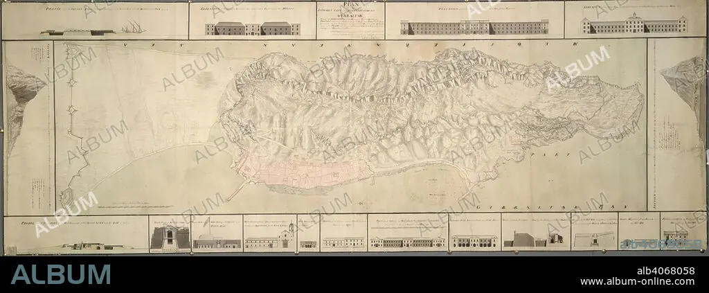
A plan of the isthmus, city and fortifications of Gibraltar. A colored "plan of the isthmus, city, and fortifications of Gibraltar, shewing elevations and sections of the principal public buildings, profiles through the two extremities of the rock, and forts built by the Spaniards; also the soundings and particular heights of the hill laid down on the plan, with several additional designs for better defending and securing the place;". 1751. Source: Maps K.Top.72.36. Language: English.
| Partager |
|---|
 Pinterest Pinterest |
 Twitter Twitter |
 Facebook Facebook |
 Copier le lien Copier le lien |
 Email Email |
|
Ajouter à une autre Lightbox |
|
Ajouter à une autre Lightbox |


Avez-vous déjà un compte? S'identifier
Vous n'avez pas de compte ? S'inscrire
Acheter cette image

Légende:
Voir la traduction automatique
A plan of the isthmus, city and fortifications of Gibraltar. A colored "plan of the isthmus, city, and fortifications of Gibraltar, shewing elevations and sections of the principal public buildings, profiles through the two extremities of the rock, and forts built by the Spaniards; also the soundings and particular heights of the hill laid down on the plan, with several additional designs for better defending and securing the place;". 1751. Source: Maps K.Top.72.36. Language: English.
Personnalités:
Crédit:
Album / British Library
Autorisations:
Modèle: Non - Propriété: Non
Questions sur les droits?
Questions sur les droits?
Taille de l'image:
10500 x 3798 px | 114.1 MB
Taille d'impression:
88.9 x 32.2 cm | 35.0 x 12.7 in (300 dpi)
Mots clés:
