alb3909134
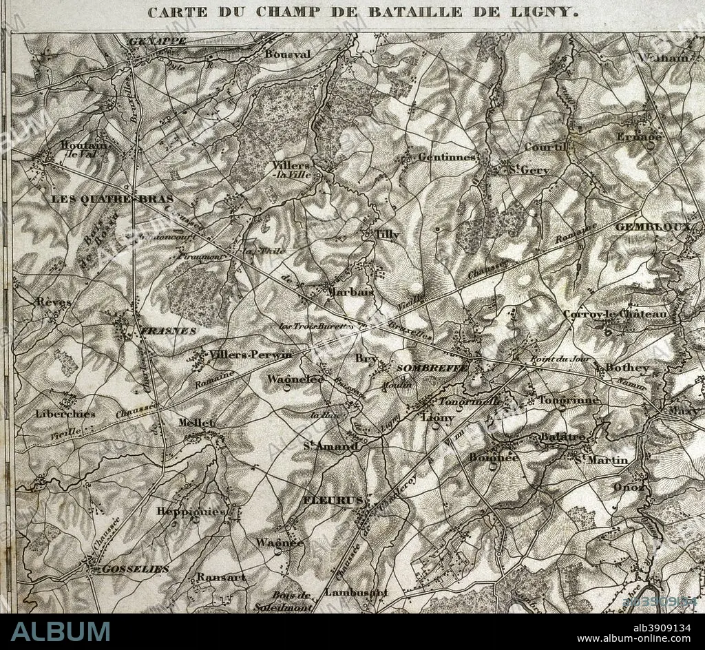
Map of the battlefield of Ligny, Belgium (16 June 1815). Part of the Waterloo Campaign. Commanders: France (Napoleon I), Prussia (Gebhard von Blucher). It was the last victory of Napoleon Bonaparte. Atlas de l'Histoire du Consulat et de l'Empire. History of the Consulate and the Empire of France under Napoleon by Marie Joseph Louis Adolphe Thiers (1797-1877). Drawings by Dufour, engravings by Dyonnet. Edited in Paris, 1864.
| Partager |
|---|
 Pinterest Pinterest |
 Twitter Twitter |
 Facebook Facebook |
 Copier le lien Copier le lien |
 Email Email |
|
Ajouter à une autre Lightbox |
|
Ajouter à une autre Lightbox |


Avez-vous déjà un compte? S'identifier
Vous n'avez pas de compte ? S'inscrire
Acheter cette image.
Sélectionnez l'usage:

Légende: Voir la traduction automatique
Map of the battlefield of Ligny, Belgium (16 June 1815). Part of the Waterloo Campaign. Commanders: France (Napoleon I), Prussia (Gebhard von Blucher). It was the last victory of Napoleon Bonaparte. Atlas de l'Histoire du Consulat et de l'Empire. History of the Consulate and the Empire of France under Napoleon by Marie Joseph Louis Adolphe Thiers (1797-1877). Drawings by Dufour, engravings by Dyonnet. Edited in Paris, 1864.
Map of the battlefield of Ligny, Belgium (16 June 1815). Part of the Waterloo Campaign. Commanders: France (Napoleon I), Prussia (Gebhard von Blucher). It was the last victory of Napoleon Bonaparte. Atlas de l'Histoire du Consulat et de l'Empire. History of the Consulate and the Empire of France under Napoleon by Marie Joseph Louis Adolphe Thiers (1797-1877). Drawings by Dufour, engravings by Dyonnet. Edited in Paris, 1864.
Personnalités: NAPOLÉON IER (1769-1821)
Crédit: Album / Prisma
Autorisations: ? Autorisation de modèle: Non - ? Autorisation de propriété: Non
Questions sur les droits?
Questions sur les droits?
Taille de l'image: 4134 × 3598 px | 42.6 MB
Taille d'impression: 35.0 × 30.5 cm | 1627.6 × 1416.5 in (300 dpi)
Mots clés: ANCIEN • ANTIQUE • ARMEE • ARMÉEE • ARMÉES • BATAILLE • BATALLE • BELGIQUE • CAMPAGNES NAPOLEONIENNES • CARTE (GEOGRAPHIE) • CARTE GEOGRAPHIQUE • CARTE • CARTOGRAPHIE • DESSIN PLANS • DESSIN • DESSINER • EUROPE • EUROPÉEN • FANCE • FRANÁAIS • FRANÁAISE • FRANCE • FRANÇAIS • FRANÇAISE • FRAVURE • GEOGRAPHIE • GRAVURE • GUERRE NAPOLEONIENNES • GUERRES NAPOLEONIENNES • HISOIRE • HISTOIRE • ILLUSTRATION • MOTIF • NAPOLÉON IER • NAPOLEON, GUERRES • PLAN (CARTOGRAPHIE) • PLANS • PRUSSIEN • SCIENCE: CARTOGRAPHIE • STRATEGIE • TECHNIQUE: DESSIN • TERRITOIRE • THIERS • XIXE SIÈCLE
