alb3800876
Map of the World, 1590
| Partager |
|---|
 Pinterest Pinterest |
 Twitter Twitter |
 Facebook Facebook |
 Copier le lien Copier le lien |
 Email Email |
|
Ajouter à une autre Lightbox |
|
Ajouter à une autre Lightbox |


Avez-vous déjà un compte? S'identifier
Vous n'avez pas de compte ? S'inscrire
Acheter cette image

Titre:
Map of the World, 1590
Légende:
Voir la traduction automatique
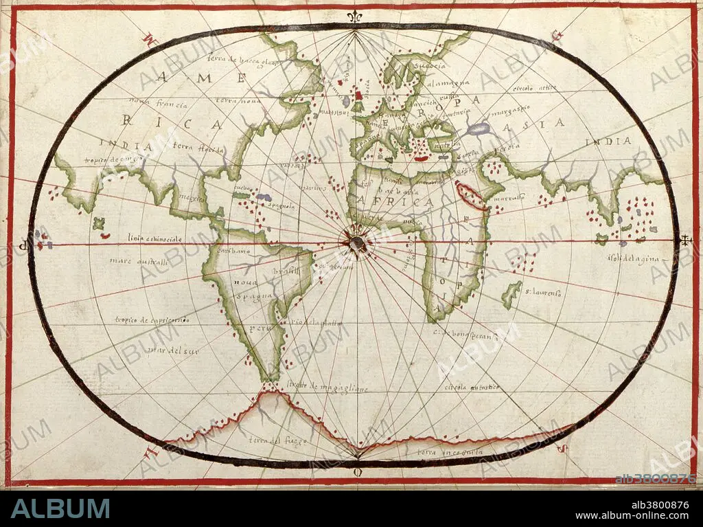
16th century map of the world. Published around 1590, this map shows the known world, including the new lands being discovered by Europeans exploring across the Atlantic and far to the East around Africa. It forms part of a portolan atlas (a collection of navigational charts) by the cartographer Joan Oliva, who was active from 1580-1615. A central compass rose lies at the meeting point of the Greenwich Meridian and the equator, and lines of longitude are seen radiating from the poles. Although the land shapes are distorted, and the map incorrectly shows southern Asia attached to North America (far left), maps like this were among the best available at the time.
Personnalités:
Crédit:
Album / Science Source / LOC/Geography and Map Division
Autorisations:
Modèle: Non - Propriété: Non
Questions sur les droits?
Questions sur les droits?
Taille de l'image:
3417 x 2384 px | 23.3 MB
Taille d'impression:
28.9 x 20.2 cm | 11.4 x 7.9 in (300 dpi)
Mots clés:
16E SIECLE • 16EME S • AMERIQUE LATINE (AMERIQUE DU SUD) • AMERIQUE LATINE • AMERIQUE • AMERIQUE, CONTINENT • ASIE • ASIE, CONTINENT • CARTE • CARTOGRAPHIE • COLONIALISME • COLONIE • CONTINENT AMERIQUE • CONTINENT ASIE • CONTINENTAL • EURASIEN • EXPLORATION • GEOGRAPHIE • MONDE • SCIENCE: CARTOGRAPHIE • SEIZIÈME SIÈCLE • XVIE SIECLE
