alb4095517
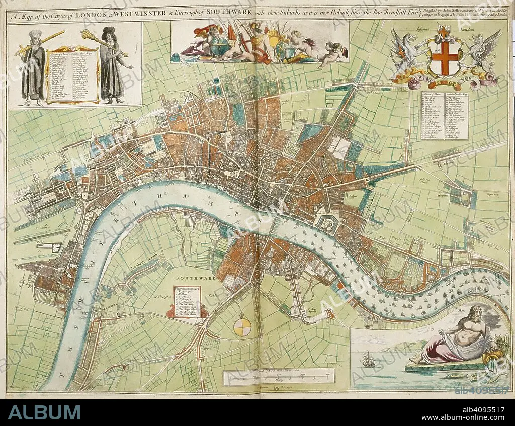
A map of the cities of London and Westminster and the Borough of Southwark with their suburbs, as it is now rebuilt since the late dreadful fire. A Collection of the County Mapps of the Kingdome of England and Principality of Wales, by John Seller (with a Map of Scotland and a Map of Ireland, a Plan of London and twenty-seven Views of its principal buildings). 1680. Source: Maps 1.TAB.18, page 4. Language: English.
| Partager |
|---|
 Pinterest Pinterest |
 Twitter Twitter |
 Facebook Facebook |
 Copier le lien Copier le lien |
 Email Email |
|
Ajouter à une autre Lightbox |
|
Ajouter à une autre Lightbox |


Avez-vous déjà un compte? S'identifier
Vous n'avez pas de compte ? S'inscrire
Acheter cette image

Auteur:
Légende:
Voir la traduction automatique
A map of the cities of London and Westminster and the Borough of Southwark with their suburbs, as it is now rebuilt since the late dreadful fire. A Collection of the County Mapps of the Kingdome of England and Principality of Wales, by John Seller (with a Map of Scotland and a Map of Ireland, a Plan of London and twenty-seven Views of its principal buildings). 1680. Source: Maps 1.TAB.18, page 4. Language: English.
Crédit:
Album / British Library
Autorisations:
Modèle: Non - Propriété: Non
Questions sur les droits?
Questions sur les droits?
Taille de l'image:
5550 x 4303 px | 68.3 MB
Taille d'impression:
47.0 x 36.4 cm | 18.5 x 14.3 in (300 dpi)
Mots clés:
17E SIECLE • 17EME S • ANGLETARRE • ANGLETERE • ANGLETERRE • ARMOIRIES (NOBLESSE) • CARTE (GEOGRAPHIE) • CARTE GEOGRAPHIQUE • CARTE • CARTOGRAPHIE • DESSIN PLANS • DIX-SEPTIÈME SIÈCLE • EUROPE • FLEUVE TAMISE • GRANDE BERTAGNE • GRANDE BRETAGNE • GRANDE-BRETAGNE • INGLATERRA • LONDRES • LONDRES, VUE SUR • LONDRES, VUE • PLAN (CARTOGRAPHIE) • PLANS • ROYAUME UNI • ROYAUME-UNI • SCIENCE: CARTOGRAPHIE • SELLER, JOHN • TAMISE • TAMISE, FLEUVE • VUE LONDRES • WESTMINSTER • XVIIE SIECLE
