alb9354753
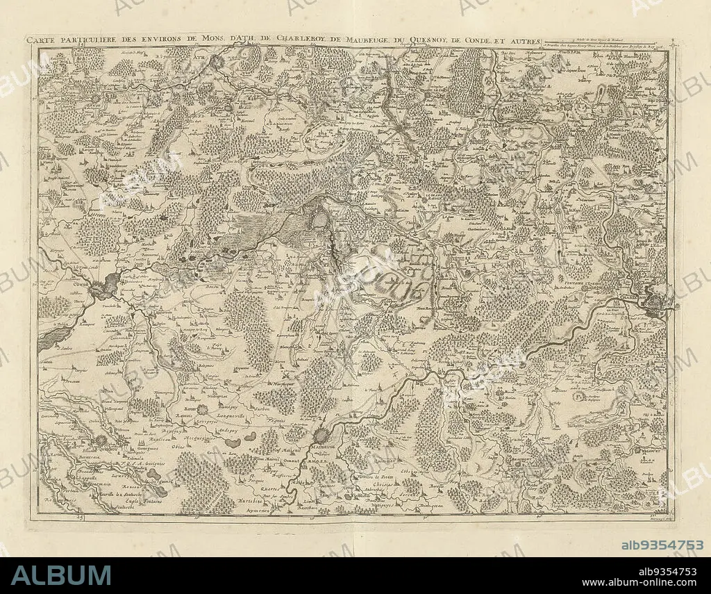
Map of Hainaut and Northern France, 1706, Carte particuliere des environs de Mons, d'Ath, de Charleroy, de Maubeuge, du Quesnoy, de Condé, et autres (title on object), Map of Hainaut and Northern France with the towns of Mons, Ath, Charleroi, Maubeuge, le Quesnoy and Condé, 1706. Part of a bundled collection of plans of battles and cities renowned in the War of the Spanish Succession. This plate is among the first 24 plates that make up a very large map of the Southern Netherlands., print maker: Jacobus Harrewijn (mentioned on object), publisher: Eugene Henry Fricx (mentioned on object), Brussels, 1706, paper, etching, engraving, height 428 mm × width 565 mm.
| Partager |
|---|
 Pinterest Pinterest |
 Twitter Twitter |
 Facebook Facebook |
 Copier le lien Copier le lien |
 Email Email |
|
Ajouter à une autre Lightbox |
|
Ajouter à une autre Lightbox |


Avez-vous déjà un compte? S'identifier
Vous n'avez pas de compte ? S'inscrire
Acheter cette image.
Sélectionnez l'usage:

Légende: Voir la traduction automatique
Map of Hainaut and Northern France, 1706, Carte particuliere des environs de Mons, d'Ath, de Charleroy, de Maubeuge, du Quesnoy, de Condé, et autres (title on object), Map of Hainaut and Northern France with the towns of Mons, Ath, Charleroi, Maubeuge, le Quesnoy and Condé, 1706. Part of a bundled collection of plans of battles and cities renowned in the War of the Spanish Succession. This plate is among the first 24 plates that make up a very large map of the Southern Netherlands., print maker: Jacobus Harrewijn (mentioned on object), publisher: Eugene Henry Fricx (mentioned on object), Brussels, 1706, paper, etching, engraving, height 428 mm × width 565 mm
Map of Hainaut and Northern France, 1706, Carte particuliere des environs de Mons, d'Ath, de Charleroy, de Maubeuge, du Quesnoy, de Condé, et autres (title on object), Map of Hainaut and Northern France with the towns of Mons, Ath, Charleroi, Maubeuge, le Quesnoy and Condé, 1706. Part of a bundled collection of plans of battles and cities renowned in the War of the Spanish Succession. This plate is among the first 24 plates that make up a very large map of the Southern Netherlands., print maker: Jacobus Harrewijn (mentioned on object), publisher: Eugene Henry Fricx (mentioned on object), Brussels, 1706, paper, etching, engraving, height 428 mm × width 565 mm
Personnalités: JACOBUS HARREWIJN
Crédit: Album / quintlox
Autorisations: ? Autorisation de modèle: Non - ? Autorisation de propriété: Non
Questions sur les droits?
Questions sur les droits?
Taille de l'image: 4896 × 3834 px | 53.7 MB
Taille d'impression: 41.5 × 32.5 cm | 1927.6 × 1509.4 in (300 dpi)
Mots clés: ASSIETTE • ASSIETTES • BRUXELLES • CARTE (GEOGRAPHIE) • CARTE GEOGRAPHIQUE • CARTE • CITE • DESSIN PLANS • FRAVURE • GRAVURE • GUERRE • JACOBUS HARREWIJN • PAPIER • PLAN (CARTOGRAPHIE) • PLANS • PLAT • PLATEAU (VAISSELLE) • VAISSELLE ASSIETTES • VILE • VILLE
