alb4546903
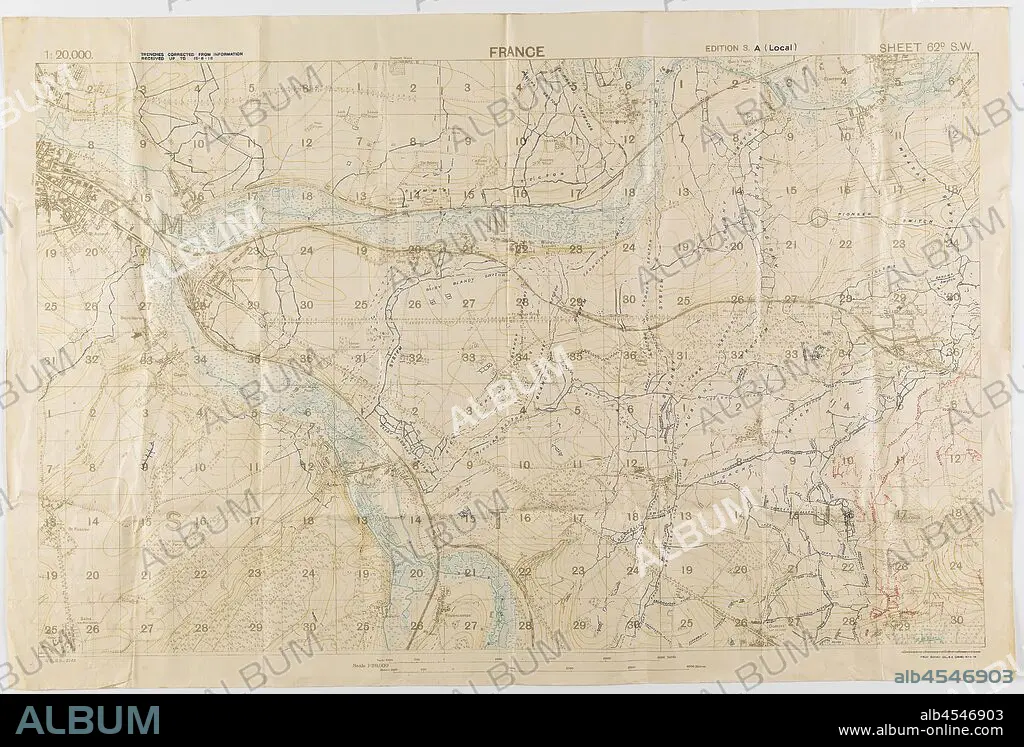
Map - Military, Trench, France, Sheet 62D SW, Scale 1:20,000, Edition 3A, World War I, 18 Jun 1918, One of two copies of a military trench map, France, sheet 62 D. S. W., edition 3.A., (local) scale 1:20,000. Trenches corrected from information received up to 15 June 1918. Field Survey Co., R. E. (3808), dated 18 June 1918. The map depicts the Somme River area to the east and south-east of Amiens, including Villers Bretonneux. Used by Capt. M. Lewis during World War I. Captain Morris Lewis,.
| Partager |
|---|
 Pinterest Pinterest |
 Twitter Twitter |
 Facebook Facebook |
 Copier le lien Copier le lien |
 Email Email |
|
Ajouter à une autre Lightbox |
|
Ajouter à une autre Lightbox |


Avez-vous déjà un compte? S'identifier
Vous n'avez pas de compte ? S'inscrire
Acheter cette image

Légende:
Voir la traduction automatique
Map - Military, Trench, France, Sheet 62D SW, Scale 1:20,000, Edition 3A, World War I, 18 Jun 1918, One of two copies of a military trench map, France, sheet 62 D. S. W., edition 3.A., (local) scale 1:20,000. Trenches corrected from information received up to 15 June 1918. Field Survey Co., R. E. (3808), dated 18 June 1918. The map depicts the Somme River area to the east and south-east of Amiens, including Villers Bretonneux. Used by Capt. M. Lewis during World War I. Captain Morris Lewis,
Personnalités:
Crédit:
Album / quintlox
Autorisations:
Modèle: Non - Propriété: Non
Questions sur les droits?
Questions sur les droits?
Taille de l'image:
3900 x 2642 px | 29.5 MB
Taille d'impression:
33.0 x 22.4 cm | 13.0 x 8.8 in (300 dpi)
Mots clés:
CARTE (GEOGRAPHIE) • CARTE GEOGRAPHIQUE • CARTE • CHATEAU: DOUVES • CRAPOUILLOT • DESSIN PLANS • DOUVES • EST • FORTIFICATION: DOUVES • FRANCE • GRANDE GUERRE • GUERRE 14-18 • GUERRE 1914-1918 • GUERRE MONDIALE I • LEWIS • ORIENT • PLAN (CARTOGRAPHIE) • PLANS • PREMIERE GUERRE MONDIALE (1914-1918) • PREMIERE GUERRE MONDIALE • TRANCHEE • TRENCH-COAT
