alb2158709
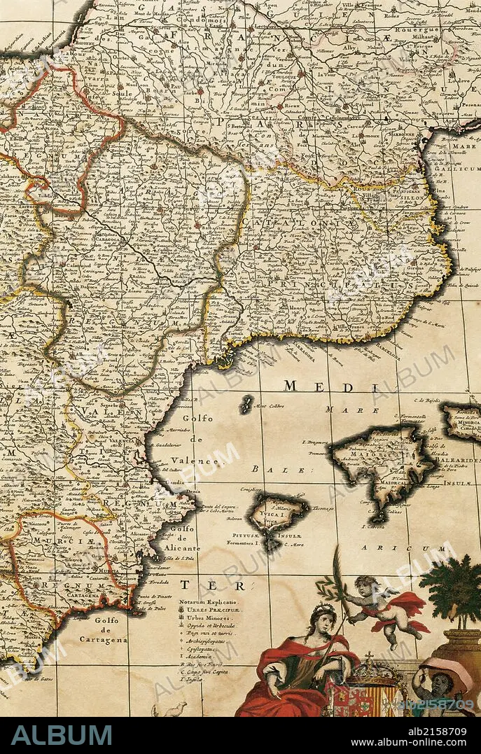
Map of the Principality of Catalonia, Kingdoms of Navarre, Aragon, Valencia, Murcia and the Balearic Islands. Atlas by Frederik de Wit (1630-1706). Amsterdam, 17th century.
| Partager |
|---|
 Pinterest Pinterest |
 Twitter Twitter |
 Facebook Facebook |
 Copier le lien Copier le lien |
 Email Email |
|
Ajouter à une autre Lightbox |
|
Ajouter à une autre Lightbox |


Avez-vous déjà un compte? S'identifier
Vous n'avez pas de compte ? S'inscrire
Acheter cette image.
Sélectionnez l'usage:

Légende:
Voir la traduction automatique
Map of the Principality of Catalonia, Kingdoms of Navarre, Aragon, Valencia, Murcia and the Balearic Islands. Atlas by Frederik de Wit (1630-1706). Amsterdam, 17th century.
Crédit:
Album / Prisma
Autorisations:
Taille de l'image:
3625 x 5400 px | 56.0 MB
Taille d'impression:
30.7 x 45.7 cm | 12.1 x 18.0 in (300 dpi)
Mots clés:
17E SIECLE • 17EME S • AMSTERDAM • CARTE (GEOGRAPHIE) • CARTE GEOGRAPHIQUE • CARTE • CARTOGRAPHIE • CATALOGNE • CÔTE • DESSIN PLANS • DETAIL • DIX-SEPTIÈME SIÈCLE • ESPAGNE, HISTOIRE • EUROPE • EUROPÉEN • HAARLEM, (NL) • HAARLEM, HOLLANDE • HISOIRE • HISTOIRE ESPAGNE • HISTOIRE HOLLANDE • HISTOIRE • HOLLANDE HAARLEM • HOLLANDE HISTOIRE • HOLLANDE • HOLLANDE, HISTOIRE • ILE • ÎLES • LITTORAL • MARITIME • MEDITERRANEAN • MÉDITERRANÉE • MÉDITERRANNÉE • MER • MURCIE • OCEAN • PAYS BAS • PAYS-BAS • PAYS-BAS, PAYSAGE • PAYSAGE MARITIME • PAYSAGE: PAYS-BAS • PLAN (CARTOGRAPHIE) • PLANS • ROYAUME • ROYAUTÉ • SCIENCE: CARTOGRAPHIE • XVIIE SIECLE
