alb9211303
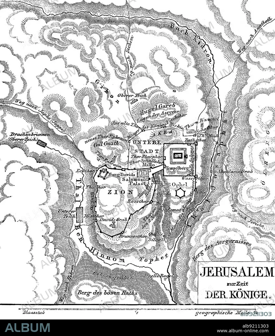
Jerusalem in the time of the kings, map, rivers, Kidron, valley, Ben Hinnom, mountains, Temple Mount, Lower City, Hill Gareb, Zion, David's Tomb, Castle of David, Solomon's Palace, Akba, Lower Pond, Upper Pond, Jericho Way, Dragon Well, scale, geographical mile, hatchings, Bible, Old Testament, Second Book of Samuelis, chapters, historical illustration c. 1850, Middle East
| Partager |
|---|
 Pinterest Pinterest |
 Twitter Twitter |
 Facebook Facebook |
 Copier le lien Copier le lien |
 Email Email |
|
Ajouter à une autre Lightbox |
|
Ajouter à une autre Lightbox |


Avez-vous déjà un compte? S'identifier
Vous n'avez pas de compte ? S'inscrire
Acheter cette image.
Sélectionnez l'usage:

Légende: Voir la traduction automatique
Jerusalem in the time of the kings, map, rivers, Kidron, valley, Ben Hinnom, mountains, Temple Mount, Lower City, Hill Gareb, Zion, David's Tomb, Castle of David, Solomon's Palace, Akba, Lower Pond, Upper Pond, Jericho Way, Dragon Well, scale, geographical mile, hatchings, Bible, Old Testament, Second Book of Samuelis, chapters, historical illustration c. 1850, Middle East
Jerusalem in the time of the kings, map, rivers, Kidron, valley, Ben Hinnom, mountains, Temple Mount, Lower City, Hill Gareb, Zion, David's Tomb, Castle of David, Solomon's Palace, Akba, Lower Pond, Upper Pond, Jericho Way, Dragon Well, scale, geographical mile, hatchings, Bible, Old Testament, Second Book of Samuelis, chapters, historical illustration c. 1850, Middle East
Personnalités: SEE • KING DAVID
Crédit: Album / ImageBroker / Wolfgang Diederich
Autorisations: ? Autorisation de modèle: Non - ? Autorisation de propriété: Non
Questions sur les droits?
Questions sur les droits?
Taille de l'image: 3882 × 4518 px | 50.2 MB
Taille d'impression: 32.9 × 38.3 cm | 1528.3 × 1778.7 in (300 dpi)
Mots clés: AMERICAIN (ETATS-UNIS) • AMERICAIN (USA) • AMÉRICAIN • ARCHITECTURE: CHATEAU • ASIE • ASIE, CONTINENT • ATTRACTION TOURISTIQUE • ATTRACTION • BASSIN • CARACTÈRE • CHAINE DE MONTAGNES • CHATEAU • CHRISTIANISME • COLLINE • CONTINENT ASIE • CORDILLÈRE • DAVID • DISTANCE • EAU LAC • ETANG • ÉTAS UNIS • ÉTAS-UNIS • ETATS UNIS • ETATS-UNIS • ILLUSTRATION • ISRAEL • JERUSALEM • JERUSALEM, (IL) VUE SUR • JERUSALEM, (IL) • JERUSALEM, VUE • KING DAVID • LAC • LACS • MASSIF • NOTES • PARC NATIONAL • PAYSAGE: JERUSALEM • PHOTOGRAPHIE DE VOYAGE • PROTECTION CIVILE • RELIGION • RESERVE NATURELLE • ROI • ROIS DE L'APOCALYPSE • SEE • SEIGNEUR • SOMMET • SOUVERAIN • U. S. A. • VALLEE • VUE JERUSALEM, (IL) • ŽTATS-UNIS
