alb9464673
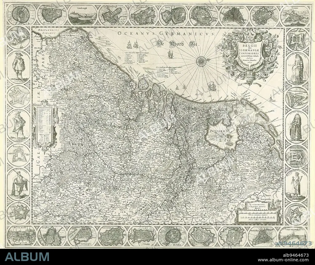
Map of the Netherlands, 1631, Belgii sive Germaniae inferioris accuratissima tabula (title on object), On the left a cartouche with an outline containing topographical information on each province. Top right title cartouche in the form of a shield surrounded by the arms of the Seventeen Provinces. Bottom right cartouche with scale bar: Milliaria Germanica communia, Milliaria Gallica communia. Degrees along the edges. In the border work maps of the most important cities and forts and six medallions with costumes of Dutch men and women, citizens and farmers. With all inscriptions in Latin. Orientation: north right., print maker: Henricus Hondius, (mentioned on object), publisher: Henricus Hondius, (mentioned on object), Amsterdam, 1631, paper, engraving, etching, height 490 mm × width 608 mm.
| Partager |
|---|
 Pinterest Pinterest |
 Twitter Twitter |
 Facebook Facebook |
 Copier le lien Copier le lien |
 Email Email |
|
Ajouter à une autre Lightbox |
|
Ajouter à une autre Lightbox |


Avez-vous déjà un compte? S'identifier
Vous n'avez pas de compte ? S'inscrire
Acheter cette image.
Sélectionnez l'usage:

Légende:
Voir la traduction automatique
Map of the Netherlands, 1631, Belgii sive Germaniae inferioris accuratissima tabula (title on object), On the left a cartouche with an outline containing topographical information on each province. Top right title cartouche in the form of a shield surrounded by the arms of the Seventeen Provinces. Bottom right cartouche with scale bar: Milliaria Germanica communia, Milliaria Gallica communia. Degrees along the edges. In the border work maps of the most important cities and forts and six medallions with costumes of Dutch men and women, citizens and farmers. With all inscriptions in Latin. Orientation: north right., print maker: Henricus Hondius, (mentioned on object), publisher: Henricus Hondius, (mentioned on object), Amsterdam, 1631, paper, engraving, etching, height 490 mm × width 608 mm
Crédit:
Album / quintlox
Autorisations:
Taille de l'image:
5662 x 4482 px | 72.6 MB
Taille d'impression:
47.9 x 37.9 cm | 18.9 x 14.9 in (300 dpi)
Mots clés:
AMSTERDAM • CARTE (GEOGRAPHIE) • CARTE GEOGRAPHIQUE • CARTE • DESSIN PLANS • FEMELLE • FEMM • FEMME • FORMULAIRE • FRAVURE • GAUCHE • GRAVURE • OBJET • ORIENTATION • PAPIER • PLAN (CARTOGRAPHIE) • PLANS • PROVINCE • PROVINS
