alb4504331
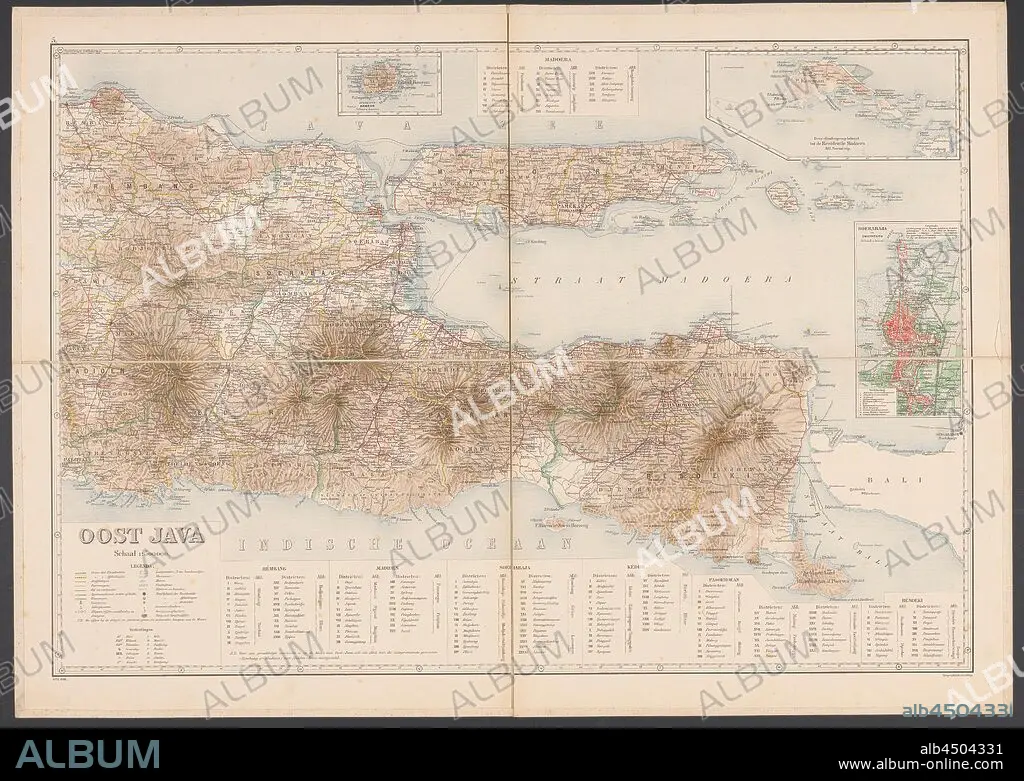
Map of East Java, Map of East Java with legend and inset maps from the area around Surabaya, the Kangean Islands and the island of Bawean. Numbered top left: 5. With degree distribution along the edges, maps of separate countries or regions, East Java, Bawean, Kangean Islands, Surabaya, Topografische Inrichting (mentioned on object), Java, 1906, paper, linen (material), h 655 mm × w 920 mm.
| Partager |
|---|
 Pinterest Pinterest |
 Twitter Twitter |
 Facebook Facebook |
 Copier le lien Copier le lien |
 Email Email |
|
Ajouter à une autre Lightbox |
|
Ajouter à une autre Lightbox |


Avez-vous déjà un compte? S'identifier
Vous n'avez pas de compte ? S'inscrire
Acheter cette image.
Sélectionnez l'usage:

Légende: Voir la traduction automatique
Map of East Java, Map of East Java with legend and inset maps from the area around Surabaya, the Kangean Islands and the island of Bawean. Numbered top left: 5. With degree distribution along the edges, maps of separate countries or regions, East Java, Bawean, Kangean Islands, Surabaya, Topografische Inrichting (mentioned on object), Java, 1906, paper, linen (material), h 655 mm × w 920 mm
Map of East Java, Map of East Java with legend and inset maps from the area around Surabaya, the Kangean Islands and the island of Bawean. Numbered top left: 5. With degree distribution along the edges, maps of separate countries or regions, East Java, Bawean, Kangean Islands, Surabaya, Topografische Inrichting (mentioned on object), Java, 1906, paper, linen (material), h 655 mm × w 920 mm
Crédit: Album / quintlox
Autorisations: ? Autorisation de modèle: Non - ? Autorisation de propriété: Non
Questions sur les droits?
Questions sur les droits?
Taille de l'image: 6000 × 4265 px | 73.2 MB
Taille d'impression: 50.8 × 36.1 cm | 2362.2 × 1679.1 in (300 dpi)
Mots clés: CARTE (GEOGRAPHIE) • CARTE GEOGRAPHIQUE • CARTE • DESSIN PLANS • ILE • ÎLES • JAVA • MATERIAU • MATÉRIEL • MATIÈRE • OBJET • PAPIER • PLAN (CARTOGRAPHIE) • PLANS • REGIONS
