alb4490654
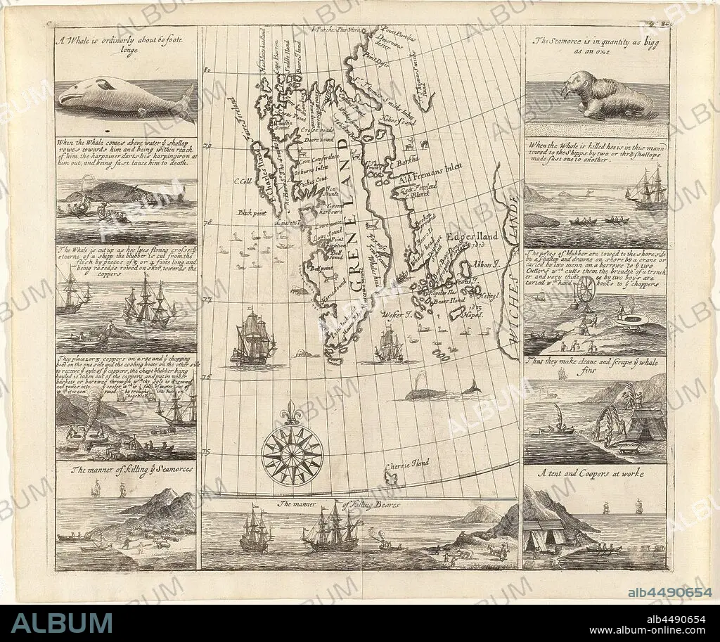
Map of Spitsbergen by Thomas Edge, 1625 Greneland (title on object), Map of the west coast of Spitsbergen (indicated on the map as 'Greneland'), with the coastline indicated as far as known. Many English toponyms are indicated along the coastline. In the sea part birds, walruses, a whale, rowing boat with four people and two ships. Reindeer and foxes on the land. A compass rose at the bottom center of the map section, pointing straight up, further on the map protractors with indications of North latitude (75 to 80). On both sides of the map section are two rows of five pictures each with scenes, mainly concerning the whale hunting, some concerning the hunting of walruses and bears. Inscriptions are written in English with each image. Below the map section an eleventh image of the hunt for polar bears, whale fishery, whaling, swimming mammals: whale, swimming mammals (with NAME), beasts of prey, predatory animals: polar bear, Spitsbergen, Thomas Edge, Northern Company, Dutch East India Company, Muscovy Company, Thomas Edge (cartograaf), London, 1625, paper, engraving, h 294 mm × w 333 mm.
| Partager |
|---|
 Pinterest Pinterest |
 Twitter Twitter |
 Facebook Facebook |
 Copier le lien Copier le lien |
 Email Email |
|
Ajouter à une autre Lightbox |
|
Ajouter à une autre Lightbox |


Avez-vous déjà un compte? S'identifier
Vous n'avez pas de compte ? S'inscrire
Acheter cette image.
Sélectionnez l'usage:

Légende:
Voir la traduction automatique
Map of Spitsbergen by Thomas Edge, 1625 Greneland (title on object), Map of the west coast of Spitsbergen (indicated on the map as 'Greneland'), with the coastline indicated as far as known. Many English toponyms are indicated along the coastline. In the sea part birds, walruses, a whale, rowing boat with four people and two ships. Reindeer and foxes on the land. A compass rose at the bottom center of the map section, pointing straight up, further on the map protractors with indications of North latitude (75 to 80). On both sides of the map section are two rows of five pictures each with scenes, mainly concerning the whale hunting, some concerning the hunting of walruses and bears. Inscriptions are written in English with each image. Below the map section an eleventh image of the hunt for polar bears, whale fishery, whaling, swimming mammals: whale, swimming mammals (with NAME), beasts of prey, predatory animals: polar bear, Spitsbergen, Thomas Edge, Northern Company, Dutch East India Company, Muscovy Company, Thomas Edge (cartograaf), London, 1625, paper, engraving, h 294 mm × w 333 mm
Crédit:
Album / quintlox
Autorisations:
Modèle: Non - Propriété: Non
Questions sur les droits?
Questions sur les droits?
Taille de l'image:
5639 x 4734 px | 76.4 MB
Taille d'impression:
47.7 x 40.1 cm | 18.8 x 15.8 in (300 dpi)
Mots clés:
ANGALIS • ANGLAIS • ANGLAISE • BALEINE • CARTE (GEOGRAPHIE) • CARTE GEOGRAPHIQUE • CARTE • CHASSE (POURSUITE) • CHÂSSE • CÔTE • DESSIN PLANS • FRAVURE • GRAVURE • LITTORAL • LOIN • LONDRES • LONDRES, VUE SUR • LONDRES, VUE • MARITIME • OBJET • OURS • PAPIER • PLAN (CARTOGRAPHIE) • PLANS • RENNE • VUE LONDRES
