alb3835587
Nile River Delta, Egypt
| Partager |
|---|
 Pinterest Pinterest |
 Twitter Twitter |
 Facebook Facebook |
 Copier le lien Copier le lien |
 Email Email |
|
Ajouter à une autre Lightbox |
|
Ajouter à une autre Lightbox |


Avez-vous déjà un compte? S'identifier
Vous n'avez pas de compte ? S'inscrire
Acheter cette image

Titre:
Nile River Delta, Egypt
Légende:
Voir la traduction automatique
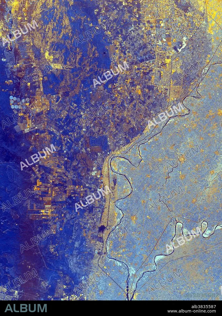
This spaceborne radar image shows the area just north of the city of Cairo, Egypt, where the Nile River splits into two main branches. The Rosetta Branch is the curving dark line in the center of the image and the Damietta Branch is the curving dark line in the lower right of the image. The light blue area on the right half of the image is a portion of the Nile River Delta. The thinner, straighter lines and the small network of gold lines are irrigation canals. There are more than 10,000 kilometers of canals throughout the Nile Delta. A transition zone of irrigated fields is shown in blue and yellow between the irrigated delta and the surrounding desert. The desert is the dark blue area on the left side of the image lacking the pattern of irrigated fields. This image was acquired by the Spaceborne Imaging Radar-C/X-band Synthetic Aperture Radar (SIR-C/X-SAR) on October 4, 1994, onboard the space shuttle Endeavour.
Crédit:
Album / Science Source / NASA/JPL
Autorisations:
Modèle: Non - Propriété: Non
Questions sur les droits?
Questions sur les droits?
Taille de l'image:
2233 x 3024 px | 19.3 MB
Taille d'impression:
18.9 x 25.6 cm | 7.4 x 10.1 in (300 dpi)
Mots clés:
