alb3897638
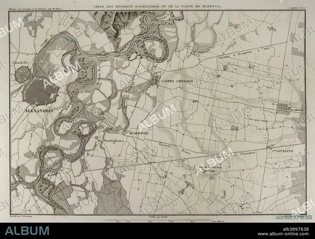
Map of the surroundings of Alessandria della Paglia and the plain of Marengo (Italian Piedmont). In this area took place the Battle of Marengo in 1800, during the War of the Second Coalition, between French and Austrian troops. Atlas de l'Histoire du Consulat et de l'Empire. History of the Consulate and the Empire of France under Napoleon by Marie Joseph Louis Adolphe Thiers (1797-1877). Drawings by Dufour, engravings by Dyonnet. Edited in Paris, 1864.
| Partager |
|---|
 Pinterest Pinterest |
 Twitter Twitter |
 Facebook Facebook |
 Copier le lien Copier le lien |
 Email Email |
|
Ajouter à une autre Lightbox |
|
Ajouter à une autre Lightbox |


Avez-vous déjà un compte? S'identifier
Vous n'avez pas de compte ? S'inscrire
Acheter cette image

Légende:
Voir la traduction automatique
Map of the surroundings of Alessandria della Paglia and the plain of Marengo (Italian Piedmont). In this area took place the Battle of Marengo in 1800, during the War of the Second Coalition, between French and Austrian troops. Atlas de l'Histoire du Consulat et de l'Empire. History of the Consulate and the Empire of France under Napoleon by Marie Joseph Louis Adolphe Thiers (1797-1877). Drawings by Dufour, engravings by Dyonnet. Edited in Paris, 1864.
Personnalités:
Crédit:
Album / Prisma
Autorisations:
Modèle: Non - Propriété: Non
Questions sur les droits?
Questions sur les droits?
Taille de l'image:
4961 x 3505 px | 49.7 MB
Taille d'impression:
42.0 x 29.7 cm | 16.5 x 11.7 in (300 dpi)
Mots clés:
ALESSANDRIA DELLA PAGLIA • ANCIEN • ANTIQUE • BATAILLE DE MARENGO • BATAILLE • BATALLE • CARTE (GEOGRAPHIE) • CARTE GEOGRAPHIQUE • CARTE • CARTOGRAPHIE • CHAMP BATAILLE • CHAMP DE BATAILLE • DESSIN PLANS • DESSIN • DESSINER • EUROPE • EUROPÉEN • FANCE • FLUVIALE • FRANCE • FRANÇAISE • FRAVURE • GEOGRAPHIE • GRAVURE • GUERRE • HISOIRE • HISTOIRE • HISTORIQUE • ITALIEN • ITALIENNE • MOTIF • NAPOLÉON IER • PLAINE • PLAN (CARTOGRAPHIE) • PLANS • SCIENCE: CARTOGRAPHIE • TECHNIQUE: DESSIN • TERRITOIRE • THIERS • XIXE SIÈCLE
