alb2994765
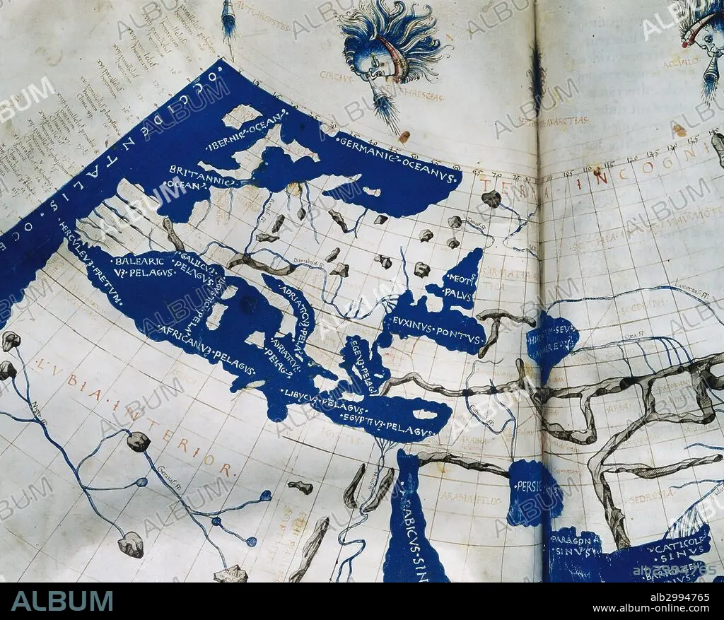
Manuscript copy of the Ptolemy (100-170 AD) world map, reconstituted from Ptolemy's Geography (c.150), indicating the countries of "Serica" and "Sinae" (China) at the extreme east, beyond the island of "Taprobane" (Sri Lanka, oversized) and the "Aurea Chersonesus" (Malay Peninsula). 15th-century.
| Partager |
|---|
 Pinterest Pinterest |
 Twitter Twitter |
 Facebook Facebook |
 Copier le lien Copier le lien |
 Email Email |
|
Ajouter à une autre Lightbox |
|
Ajouter à une autre Lightbox |


Avez-vous déjà un compte? S'identifier
Vous n'avez pas de compte ? S'inscrire
Acheter cette image.
Sélectionnez l'usage:

Légende: Voir la traduction automatique
Manuscript copy of the Ptolemy (100-170 AD) world map, reconstituted from Ptolemy's Geography (c.150), indicating the countries of "Serica" and "Sinae" (China) at the extreme east, beyond the island of "Taprobane" (Sri Lanka, oversized) and the "Aurea Chersonesus" (Malay Peninsula). 15th-century.
Manuscript copy of the Ptolemy (100-170 AD) world map, reconstituted from Ptolemy's Geography (c.150), indicating the countries of "Serica" and "Sinae" (China) at the extreme east, beyond the island of "Taprobane" (Sri Lanka, oversized) and the "Aurea Chersonesus" (Malay Peninsula). 15th-century.
Personnalités: GRECO-EGYPTIAN
Crédit: Album / Prisma
Autorisations: ? Autorisation de modèle: Non - ? Autorisation de propriété: Non
Questions sur les droits?
Questions sur les droits?
Taille de l'image: 5123 × 4121 px | 60.4 MB
Taille d'impression: 43.4 × 34.9 cm | 2016.9 × 1622.4 in (300 dpi)
Mots clés: 15 15E 15EME XV XVE XVEME SIECLE • 15E SIECLE • 15EME S • 2E SIECLE • 2ND S • AFRIQUE DU NORD • ANCIEN • ANTIQUE • ANTIQUITE • ANTIQUITÉS • ART PERSAN • ASIE • ASIE, CONTINENT • ASTROLOGUE • ASTRONOMIE • CARTE (GEOGRAPHIE) • CARTE GEOGRAPHIQUE • CARTE • CARTOGRAPHIE • CONTINENT ASIE • DESSIN PLANS • DEUXIÈME SIÈCLE • ECRITURE MANUSCRITS (MSS) • EUROPE • FLEUVE • FRAVURE • GEOGRAPHE • GEOGRAPHIE • GRAVURE • GRECO-EGYPTIAN • HISOIRE • HISTOIRE • HISTORIQUE • IIE SIECLE • ILE • ÎLES • MANUSCRITS • MAPPEMONDE • MATHEMATICIEN • MATHÉMATIQUE • MÉDITERRANÉE • MYTHES: PERSES • PERSAN • PERSE • PERSES • PERSES, MYTHES • PLAN (CARTOGRAPHIE) • PLANISPHERE • PLANS • QUINZIÈME SIÈCLE • RIO • RIVIÈRE FLEUVE • RIVIERE • RIVIRE • RIVIRE • SCIENCE: ASTRONOMIE • SCIENCE: CARTOGRAPHIE • SRI LANKA • XVE SIECLE
