alb5480343
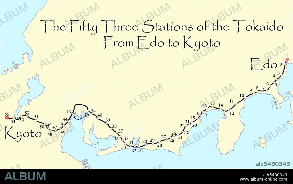
Map of the 'Fifty Three Stations of the Tokaido', or East Sea Highway linking Edo (Tokyo) to Kyoto during the 18th and 19th centuries.
| Partager |
|---|
 Pinterest Pinterest |
 Twitter Twitter |
 Facebook Facebook |
 Copier le lien Copier le lien |
 Email Email |
|
Ajouter à une autre Lightbox |
|
Ajouter à une autre Lightbox |


Avez-vous déjà un compte? S'identifier
Vous n'avez pas de compte ? S'inscrire
Acheter cette image

Titre:
Map of the 'Fifty Three Stations of the Tokaido', or East Sea Highway linking Edo (Tokyo) to Kyoto during the 18th and 19th centuries.
Légende:
Voir la traduction automatique
Map of the 'Fifty Three Stations of the Tokaido' between Edo (Tokyo) and Kyoto. The Ti kaidi (East Sea Road) was the most important of the Five Routes of the Edo period, connecting Edo (modern-day Tokyo) to Kyoto in Japan. Unlike the inland and less heavily travelled Nakasendi, the Ti kaidi travelled along the sea coast of eastern Honshu, hence the route's name.
Crédit:
Album / Pictures From History/Universal Images Group
Autorisations:
Modèle: Non - Propriété: Non
Questions sur les droits?
Questions sur les droits?
Taille de l'image:
5500 x 3176 px | 50.0 MB
Taille d'impression:
46.6 x 26.9 cm | 18.3 x 10.6 in (300 dpi)
Mots clés:
ASIE • ASIE, CONTINENT • CARTE (GEOGRAPHIE) • CARTE GEOGRAPHIQUE • CARTE • CARTOGRAPHIE • CONTINENT ASIE • DESSIN PLANS • HISOIRE • HISTOIRE • JAPON • JAPONAIS • JAPONAISE • METIER • ORNEMENT, JAPONAIS • PLAN (CARTOGRAPHIE) • PLANS • SCIENCE: CARTOGRAPHIE • TOKIO • TOKYO • TRANSPORT
