alb5530966
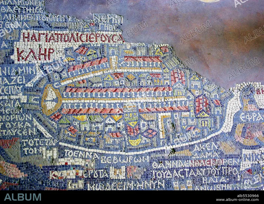
Jordan / Israel / Palestine: Detail of the Madaba Mosaic Map showing Old Jerusalem protected by oval-shaped city walls. Church of St George, Madaba,6th century CE. Photo by Berthold Werner (CC BY 3.0)
| Partager |
|---|
 Pinterest Pinterest |
 Twitter Twitter |
 Facebook Facebook |
 Copier le lien Copier le lien |
 Email Email |
|
Ajouter à une autre Lightbox |
|
Ajouter à une autre Lightbox |


Avez-vous déjà un compte? S'identifier
Vous n'avez pas de compte ? S'inscrire
Acheter cette image.
Sélectionnez l'usage:

Titre: Jordan / Israel / Palestine: Detail of the Madaba Mosaic Map showing Old Jerusalem protected by oval-shaped city walls. Church of St George, Madaba,6th century CE. Photo by Berthold Werner (CC BY 3.0)
Légende: Voir la traduction automatique
The Madaba Map (also known as the Madaba Mosaic Map) is part of a floor mosaic in the early Byzantine church of Saint George at Madaba, Jordan. The Madaba Map is a map of the Middle East. Part of it contains the oldest surviving original cartographic depiction of the Holy Land and especially Jerusalem. It dates to the 6th century CE.
The Madaba Map (also known as the Madaba Mosaic Map) is part of a floor mosaic in the early Byzantine church of Saint George at Madaba, Jordan. The Madaba Map is a map of the Middle East. Part of it contains the oldest surviving original cartographic depiction of the Holy Land and especially Jerusalem. It dates to the 6th century CE.
Crédit: Album / Pictures From History/Universal Images Group
Autorisations: ? Autorisation de modèle: Non - ? Autorisation de propriété: Non
Questions sur les droits?
Questions sur les droits?
Taille de l'image: 5000 × 3602 px | 51.5 MB
Taille d'impression: 42.3 × 30.5 cm | 1968.5 × 1418.1 in (300 dpi)
Mots clés: 6E SIECLE • 6EME S • ASIE • ASIE, CONTINENT • BYZANTIN • BYZANTINE • CARTE (GEOGRAPHIE) • CARTE GEOGRAPHIQUE • CARTE • CARTES • CARTOGRAPHIE • CONTINENT ASIE • DESSIN PLANS • ISRAEL • JERUSALEM • JERUSALEM, (IL) VUE SUR • JERUSALEM, (IL) • JERUSALEM, VUE • JUIF (ADJECTIF) • JUIF • JUIFS (NOM) • JUIFS • JUIVE • LEVANT • PALESTINE • PALESTINIEN (S) • PALESTINIEN • PALESTINIENNE • PAYSAGE: JERUSALEM • PLAN (CARTOGRAPHIE) • PLANS • PROCHE-ORIENT • RELIGION • SCIENCE: CARTOGRAPHIE • VUE JERUSALEM, (IL)
