alb4859284
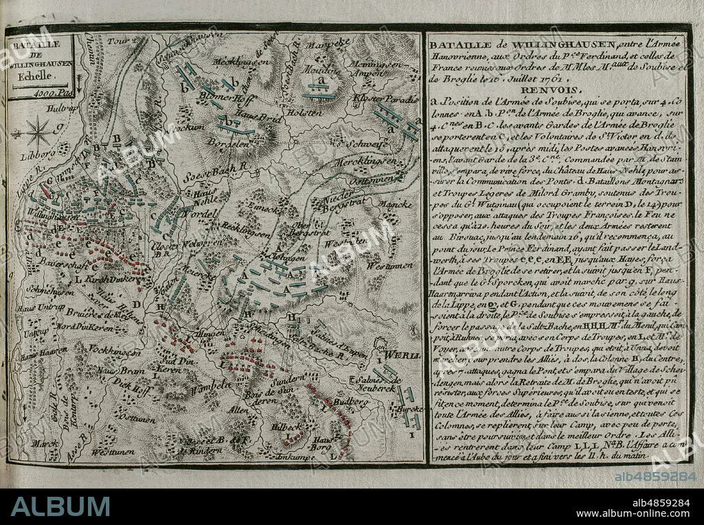
JEAN DE BEAURAIN (1696-1771). FRENCH GEOGRAPHER.. Seven Years War (1756-1763). Map of the Battle of Vellinghausen (July 15-16, 1761). It took place on the banks of the Lippe River in North West Germany. Confronted the allied Prussian-Hanoverian-British army led by Prince Ferdinand of Brunswick against the French army under the command of the Duc de Broglie and the Prince Soubise. The French force had to retreat. Published in 1765 by the cartographer Jean de Beaurain (1696-1771) as an illustration of his Great Map of Germany, with the events that took place during the Seven Years War. Allied army in red and the French army in blue. Etching and engraving. French edition, 1765. Military Historical Library of Barcelona (Biblioteca Histórico Militar de Barcelona). Catalonia. Spain.
| Partager |
|---|
 Pinterest Pinterest |
 Twitter Twitter |
 Facebook Facebook |
 Copier le lien Copier le lien |
 Email Email |
|
Ajouter à une autre Lightbox |
|
Ajouter à une autre Lightbox |


Avez-vous déjà un compte? S'identifier
Vous n'avez pas de compte ? S'inscrire
Acheter cette image.
Sélectionnez l'usage:

Légende: Voir la traduction automatique
Seven Years War (1756-1763). Map of the Battle of Vellinghausen (July 15-16, 1761). It took place on the banks of the Lippe River in North West Germany. Confronted the allied Prussian-Hanoverian-British army led by Prince Ferdinand of Brunswick against the French army under the command of the Duc de Broglie and the Prince Soubise. The French force had to retreat. Published in 1765 by the cartographer Jean de Beaurain (1696-1771) as an illustration of his Great Map of Germany, with the events that took place during the Seven Years War. Allied army in red and the French army in blue. Etching and engraving. French edition, 1765. Military Historical Library of Barcelona (Biblioteca Histórico Militar de Barcelona). Catalonia. Spain.
Seven Years War (1756-1763). Map of the Battle of Vellinghausen (July 15-16, 1761). It took place on the banks of the Lippe River in North West Germany. Confronted the allied Prussian-Hanoverian-British army led by Prince Ferdinand of Brunswick against the French army under the command of the Duc de Broglie and the Prince Soubise. The French force had to retreat. Published in 1765 by the cartographer Jean de Beaurain (1696-1771) as an illustration of his Great Map of Germany, with the events that took place during the Seven Years War. Allied army in red and the French army in blue. Etching and engraving. French edition, 1765. Military Historical Library of Barcelona (Biblioteca Histórico Militar de Barcelona). Catalonia. Spain.
Emplacement: Historical Military Library of Barcelona. Catalonia. Spain.
Crédit: Album / Prisma
Autorisations: ? Autorisation de modèle: Non - ? Autorisation de propriété: Non
Questions sur les droits?
Questions sur les droits?
Taille de l'image: 4724 × 3277 px | 44.3 MB
Taille d'impression: 40.0 × 27.7 cm | 1859.8 × 1290.2 in (300 dpi)
Mots clés: 18 18E 18EME XVIII XVIIIE XVIIIEME SIECLE • 18E SIECLE • 18EME S • ALLEMAGNE • ALLEMAND • ALLEMANDE • ANCIEN • ANGALIS • ANGLAIS • ANGLAISE • ANTIQUE • ARMEE, FRANCAISE • BATAILLE • BATALLE • CARTE (GEOGRAPHIE) • CARTE GEOGRAPHIQUE • CARTE • CARTOGRAPHIE • COLONIALISME • CONFLICTS • CONFLIT • DESSIN PLANS • DIX-HUITIÈME SIÈCLE • EUROPE • EUROPÉEN • FANCE • FRANCE • FRANCE, HISTOIRE • FRANÇAISE • FRAVURE • GRAVURE • GUERRE COLONIALE • GUERRE DE SEPT ANS • GUERRE • HISOIRE • HISTOIRE FRANCE • HISTOIRE • HISTORICAL MILITARY LIBRARY OF BARCELONA. CATALONIA. SPAIN. • JEAN DE BEAURAIN (1696-1771). FRENCH GEOGRAPHER. • NORTH RHINE-WESTPHALI • PLAN (CARTOGRAPHIE) • PLANS • SCIENCE: CARTOGRAPHIE • STRATEGIE • VELLINGHAUSEN • XVIIIE SIECLE
