alb5938969
ANONYME. Peutinger Table / 9th Sheet / 1264
| Partager |
|---|
 Pinterest Pinterest |
 Twitter Twitter |
 Facebook Facebook |
 Copier le lien Copier le lien |
 Email Email |
|
Ajouter à une autre Lightbox |
|
Ajouter à une autre Lightbox |


Avez-vous déjà un compte? S'identifier
Vous n'avez pas de compte ? S'inscrire
Acheter cette image.
Sélectionnez l'usage:

Auteur:
Titre:
Peutinger Table / 9th Sheet / 1264
Légende:
Voir la traduction automatique
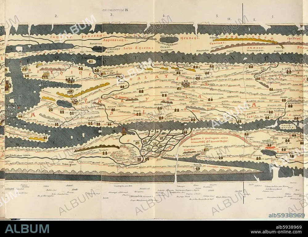
Geography / Maps of the World. Peutinger Table (copy of a map of the Romam empire (version of C3rd AD) made in 1264); 9th sheet: Asia Minor and Egypt. Colour lithograph. From: World map of Castorius, called the Peutinger Table, published by Konrad Miller, Ravensburg (O.Maier) 1888. Berlin, Museum für Kommunikation.
Projet:
MAPAMUNDI DE CASTORIUS
Technique/matériel:
ARTS GRAPHIQUES • IMPRIME
Musée:
Berlin, Museum für Kommunikation
Crédit:
Album / akg-images
Autorisations:
Modèle: Non - Propriété: Non
Questions sur les droits?
Questions sur les droits?
Taille de l'image:
4961 x 3555 px | 50.5 MB
Taille d'impression:
42.0 x 30.1 cm | 16.5 x 11.8 in (300 dpi)
Mots clés:
13E SIECLE • 13EME S • 2E MILLENAIRE • 3E SIECLE • ALEXANDRIE (EGYPTE) • ANONYME • ANTIQUITE • ANTIQUITÉS • ARTS GRAPHIQUES • ASIE MINEURE • BERLIN • BERLIN, MUSEUM FÜR KOMMUNIKATION • CARTE ROUTIERE • CARTE • CARTOGRAPHIE • CIRCULATION ET TRANSPORTS • CIRCULATION • DEUXIEME MILLENAIRE • EGYPTE • EMPIRE BYZANTIN • EMPIRE ROMAIN • GEOGRAPHIE • IMPRIME • KONRAD MILLER • LITHOGRAPHIE • MAPAMUNDI DE CASTORIUS • MAPPEMONDE • PERIODE: ROME IMPERIALE • PHARE (MER) • PHARE • PLANISPHERE • RESEAU ROUTIER • ROME, IMPERIALE • SCIENCE: CARTOGRAPHIE • TRANSPORTS • TREIZIÈME SIÈCLE • VUE PARTIELLE • XIIIE SIECLE
