alb5409865
Diogo Ribeiro, Map of the Americas,1529
| Partager |
|---|
 Pinterest Pinterest |
 Twitter Twitter |
 Facebook Facebook |
 Copier le lien Copier le lien |
 Email Email |
|
Ajouter à une autre Lightbox |
|
Ajouter à une autre Lightbox |


Avez-vous déjà un compte? S'identifier
Vous n'avez pas de compte ? S'inscrire
Acheter cette image.
Sélectionnez l'usage:

Titre: Diogo Ribeiro, Map of the Americas,1529
Légende: Voir la traduction automatique
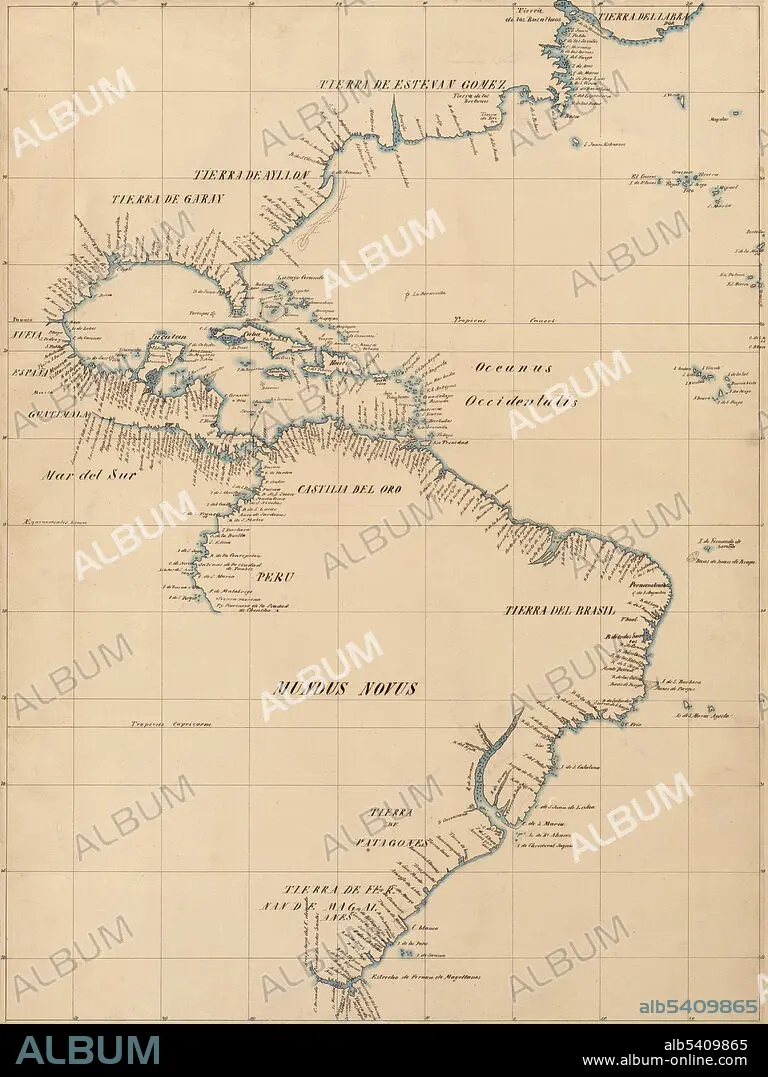
Detail of the American coast from Diogo Ribeiro's 1529 map. Pen-and-ink and blue watercolor, mounted on cloth, mounted on paper. Traced by Johann Georg Kohl from a map by Diogo Ribeiro, 1840. Diogo Ribeiro was a Portuguese cartographer and explorer who worked most of his life in Spain. He worked on the official maps of the Padrón Real (or Padrón General) from 1518-1532. The layout of the map (Mapamundi) is strongly influenced by the information obtained during the Magellan-Elcano trip around the world. The map delineates very precisely the coasts of Central and South America. It shows the whole east coast of the Americas but of the west coast only the area from Guatemala to Ecuador. The map shows, for the first time, the North American coast as a continuous one.
Detail of the American coast from Diogo Ribeiro's 1529 map. Pen-and-ink and blue watercolor, mounted on cloth, mounted on paper. Traced by Johann Georg Kohl from a map by Diogo Ribeiro, 1840. Diogo Ribeiro was a Portuguese cartographer and explorer who worked most of his life in Spain. He worked on the official maps of the Padrón Real (or Padrón General) from 1518-1532. The layout of the map (Mapamundi) is strongly influenced by the information obtained during the Magellan-Elcano trip around the world. The map delineates very precisely the coasts of Central and South America. It shows the whole east coast of the Americas but of the west coast only the area from Guatemala to Ecuador. The map shows, for the first time, the North American coast as a continuous one.
Crédit: Album / Science Source / LOC/Geography and Map Division
Autorisations: ? Autorisation de modèle: Non - ? Autorisation de propriété: Non
Questions sur les droits?
Questions sur les droits?
Taille de l'image: 3263 × 4350 px | 40.6 MB
Taille d'impression: 27.6 × 36.8 cm | 1284.6 × 1712.6 in (300 dpi)
Mots clés: 16E SIECLE • 16EME S • AMERIQUE • AMERIQUE, CONTINENT • CARTE • CARTOGRAPHIE • CÉLÈBRE • CELEBRITE • CONTINENT AMERIQUE • GEOGRAPHIE • NAVIGATION • SCIENCE: CARTOGRAPHIE • SEIZIÈME SIÈCLE • XVIE SIECLE
