alb3907891
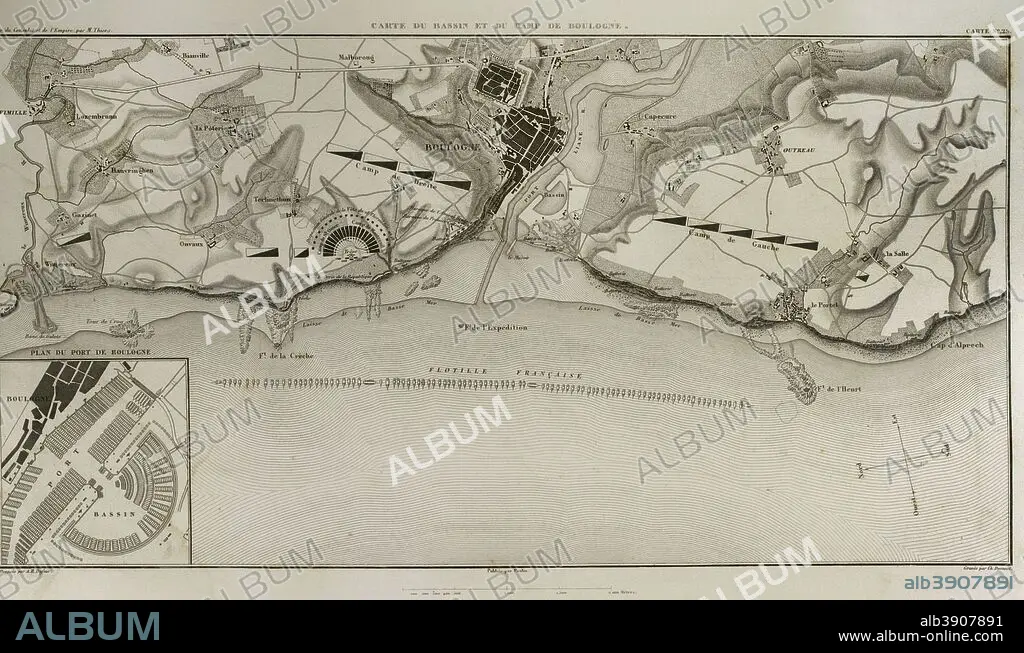
Map of Boulogne-sur-Mer. In French coast on the English Channel. it was a staging area for Napoleon's troops for several months in 1805, during his planned invasion of the United Kingdom. Atlas de l'Histoire du Consulat et de l'Empire. History of the Consulate and the Empire of France under Napoleon by Marie Joseph Louis Adolphe Thiers (1797-1877). Drawings by Dufour, engravings by Dyonnet. Edited in Paris, 1864.
| Partager |
|---|
 Pinterest Pinterest |
 Twitter Twitter |
 Facebook Facebook |
 Copier le lien Copier le lien |
 Email Email |
|
Ajouter à une autre Lightbox |
|
Ajouter à une autre Lightbox |


Avez-vous déjà un compte? S'identifier
Vous n'avez pas de compte ? S'inscrire
Acheter cette image.
Sélectionnez l'usage:

Légende:
Voir la traduction automatique
Map of Boulogne-sur-Mer. In French coast on the English Channel. it was a staging area for Napoleon's troops for several months in 1805, during his planned invasion of the United Kingdom. Atlas de l'Histoire du Consulat et de l'Empire. History of the Consulate and the Empire of France under Napoleon by Marie Joseph Louis Adolphe Thiers (1797-1877). Drawings by Dufour, engravings by Dyonnet. Edited in Paris, 1864.
Personnalités:
Crédit:
Album / Prisma
Autorisations:
Taille de l'image:
5079 x 2977 px | 43.3 MB
Taille d'impression:
43.0 x 25.2 cm | 16.9 x 9.9 in (300 dpi)
Mots clés:
ANCIEN • ANGLETARRE • ANGLETERE • ANGLETERRE • ANTIQUE • ARMADA • ARMEE • ARMÉEE • ARMÉES • AUTEUR • AUTEURS • BATEAU FLOTTE • BOULOGNE-SUR-MER • CAMPAGNES NAPOLEONIENNES • CARTE (GEOGRAPHIE) • CARTE GEOGRAPHIQUE • CARTE • CARTOGRAPHIE • CÔTE • DESSIN PLANS • DESSIN • DESSINER • EUROPE • EUROPÉEN • FANCE • FLOTTE • FLOTTILLE • FRANCE • FRANÇAISE • FRAVURE • GEOGRAPHIE • GRANDE ARMEE • GRANDE BERTAGNE • GRANDE BRETAGNE • GRANDE-BRETAGNE • GRAVURE • GUERRE NAPOLEONIENNES • GUERRE • GUERRES NAPOLEONIENNES • HISOIRE • HISTOIRE • ILLUSTRATION • INGLATERRA • INVASION MILITAIRE • INVASION • LITTORAL • MARINE (MILITAIRE) • MARINE UNIFORMES • MARITIME • MOTIF • NAPOLÉON IER • NAPOLEON, GUERRES • PARIS • PARIS, FRANCE • PLAN (CARTOGRAPHIE) • PLANS • ROYAUME UNI • ROYAUME-UNI • SCIENCE: CARTOGRAPHIE • STRATEGIE • TECHNIQUE: DESSIN • TERRITOIRE • THIERS • UNIFORMES MARINE • VETEMENT: UNIFORMES MARINE • XIXE SIÈCLE
