alb5595318
ANONYME. Map of the Battle near Roßbach / 1757
| Partager |
|---|
 Pinterest Pinterest |
 Twitter Twitter |
 Facebook Facebook |
 Copier le lien Copier le lien |
 Email Email |
|
Ajouter à une autre Lightbox |
|
Ajouter à une autre Lightbox |


Avez-vous déjà un compte? S'identifier
Vous n'avez pas de compte ? S'inscrire
Acheter cette image.
Sélectionnez l'usage:

Auteur:
Titre:
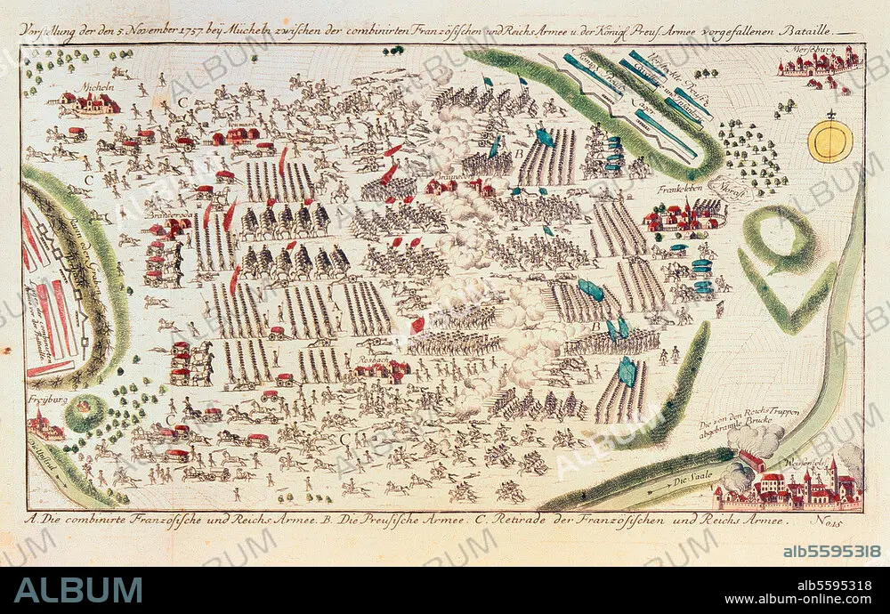
Map of the Battle near Roßbach / 1757
Légende:
Voir la traduction automatique
Seven Year War 1756-63 / Battle near Rossbach 5 Nov. 1757 (Frederick the Great defeats the French led by Soubise and the Imperial Army). Map of the battle. Copper engraving, coloured. 40 × 24cm. Merseburg, Zentrales Staatsarchiv.
Technique/matériel:
ARTS GRAPHIQUES • IMPRIME • GRAVURE SUR CUIVRE
Musée:
Merseburg, Zentrales Staatsarchiv
Crédit:
Album / akg-images
Autorisations:
Modèle: Non - Propriété: Non
Questions sur les droits?
Questions sur les droits?
Taille de l'image:
4059 x 2585 px | 30.0 MB
Taille d'impression:
34.4 x 21.9 cm | 13.5 x 8.6 in (300 dpi)
Mots clés:
18 18E 18EME XVIII XVIIIE XVIIIEME SIECLE • 18E SIECLE • 18EME S • 2E MILLENAIRE • ALLEMAGNE • ANONYME • ARTS GRAPHIQUES • AUTRICHE • BATAILLE • BATALLE • CARTE (GEOGRAPHIE) • CARTE GEOGRAPHIQUE • CARTE • DESSIN PLANS • DEUXIEME MILLENAIRE • DIX-HUITIÈME SIÈCLE • EVENEMENT HISTORIQUE • FEDERICO II EL GRANDE • FRANCE • GRAVURE SUR CUIVRE • GUERRE DE SEPT ANS • GUERRE • HISOIRE • HISTOIRE • IMPRIME • MERSEBURG • MERSEBURG, ZENTRALES STAATSARCHIV • MILITAIRE • PLAN (CARTOGRAPHIE) • PLAN DE BATAILLE • PLANS • PRUSSE • ROSSBACH • STRATEGIE • VIE MILITAIRE ET ARMEMENT • XVIIIE SIECLE
