alb9006366
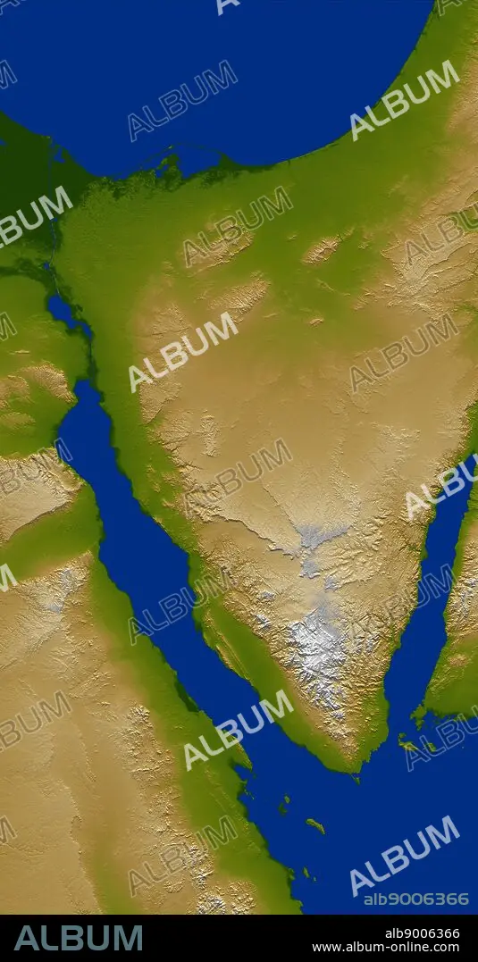
The Sinai Peninsula, located between Africa and Asia, is a result of those two continents pulling apart from each other. Earth's crust is cracking, stretching, and lowering along the two northern branches of the Red Sea, namely the Gulf of Suez, seen here on the west (left), and the Gulf of Aqaba, seen to the east (right). This color-coded shaded relief image shows the triangular nature of the peninsula, with the coast of the Mediterranean Sea forming the northern side of the triangle. The Suez Canal can be seen as the narrow vertical blue line in the upper left connecting the Red Sea to the Mediterranean.
| Partager |
|---|
 Pinterest Pinterest |
 Twitter Twitter |
 Facebook Facebook |
 Copier le lien Copier le lien |
 Email Email |
|
Ajouter à une autre Lightbox |
|
Ajouter à une autre Lightbox |


Avez-vous déjà un compte? S'identifier
Vous n'avez pas de compte ? S'inscrire
Acheter cette image.
Sélectionnez l'usage:

Légende:
Voir la traduction automatique
The Sinai Peninsula, located between Africa and Asia, is a result of those two continents pulling apart from each other. Earth's crust is cracking, stretching, and lowering along the two northern branches of the Red Sea, namely the Gulf of Suez, seen here on the west (left), and the Gulf of Aqaba, seen to the east (right). This color-coded shaded relief image shows the triangular nature of the peninsula, with the coast of the Mediterranean Sea forming the northern side of the triangle. The Suez Canal can be seen as the narrow vertical blue line in the upper left connecting the Red Sea to the Mediterranean.
Crédit:
Album / World History Archive
Autorisations:
Taille de l'image:
3100 x 5937 px | 52.7 MB
Taille d'impression:
26.2 x 50.3 cm | 10.3 x 19.8 in (300 dpi)
