alb3847160
Madrid, Meseta Central Plateau, SRTM Image
| Partager |
|---|
 Pinterest Pinterest |
 Twitter Twitter |
 Facebook Facebook |
 Copier le lien Copier le lien |
 Email Email |
|
Ajouter à une autre Lightbox |
|
Ajouter à une autre Lightbox |


Avez-vous déjà un compte? S'identifier
Vous n'avez pas de compte ? S'inscrire
Acheter cette image.
Sélectionnez l'usage:

Titre: Madrid, Meseta Central Plateau, SRTM Image
Légende: Voir la traduction automatique
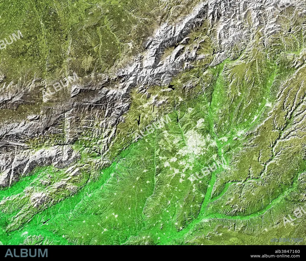
The white, mottled area in the right-center of this image is Madrid. Located on the Meseta Central, a vast plateau covering about 40 percent of the country, this city of 3 million is very near the exact geographic center of the Iberian Peninsula. The Meseta is rimmed by mountains and slopes gently to the west and to the series of rivers that form the boundary with Portugal. The plateau is mostly covered with dry grasslands, olive groves and forested hills. To the northwest of Madrid, and visible in the upper left of the image, is the Sistema Central mountain chain. Rising to about 8,200 feet, these mountains display some glacial features and are snow-capped for most of the year. Three visualization methods were combined to produce this image: shading and color coding of topographic height and radar image intensity. Color coding is directly related to topographic height, with green at the lower elevations, rising through yellow and brown to white at the highest elevations. The shade image was combined with the radar intensity image in the flat areas. Elevation data was acquired by the SRTM aboard the Endeavour, launched on Feb. 11, 2000.
The white, mottled area in the right-center of this image is Madrid. Located on the Meseta Central, a vast plateau covering about 40 percent of the country, this city of 3 million is very near the exact geographic center of the Iberian Peninsula. The Meseta is rimmed by mountains and slopes gently to the west and to the series of rivers that form the boundary with Portugal. The plateau is mostly covered with dry grasslands, olive groves and forested hills. To the northwest of Madrid, and visible in the upper left of the image, is the Sistema Central mountain chain. Rising to about 8,200 feet, these mountains display some glacial features and are snow-capped for most of the year. Three visualization methods were combined to produce this image: shading and color coding of topographic height and radar image intensity. Color coding is directly related to topographic height, with green at the lower elevations, rising through yellow and brown to white at the highest elevations. The shade image was combined with the radar intensity image in the flat areas. Elevation data was acquired by the SRTM aboard the Endeavour, launched on Feb. 11, 2000.
Crédit: Album / Science Source / NASA/JPL
Autorisations: ? Autorisation de modèle: Non - ? Autorisation de propriété: Non
Questions sur les droits?
Questions sur les droits?
Taille de l'image: 2500 × 2000 px | 14.3 MB
Taille d'impression: 21.2 × 16.9 cm | 984.3 × 787.4 in (300 dpi)
Mots clés: AÉRIEN • ESPAGNE • GEOGRAPHIE • GEOLOGIE • MADRID • PORTUGAL • TOPOGRAPHIE
