alb5651519
ANONYME. Line of Defence Siegfried Line / Map
| Partager |
|---|
 Pinterest Pinterest |
 Twitter Twitter |
 Facebook Facebook |
 Copier le lien Copier le lien |
 Email Email |
|
Ajouter à une autre Lightbox |
|
Ajouter à une autre Lightbox |


Avez-vous déjà un compte? S'identifier
Vous n'avez pas de compte ? S'inscrire
Acheter cette image.
Sélectionnez l'usage:

Auteur: Anonyme
Titre: Line of Defence Siegfried Line / Map
Légende: Voir la traduction automatique
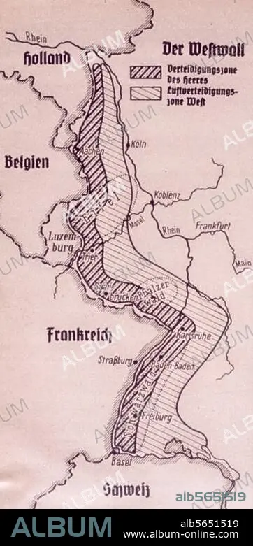
Germany / Siegfried Line (Westwall). (ring of fortifications at the Western frontier fr. Aachen to the Swiss border; built from May 1938 to August 1939 by order of Hitler). Map showing the defence area of the Siegfried Line (Westwall). Print, fr.: magazine "Der Schulungsbrief", 6th year, 10th issue, 1939.
Germany / Siegfried Line (Westwall). (ring of fortifications at the Western frontier fr. Aachen to the Swiss border; built from May 1938 to August 1939 by order of Hitler). Map showing the defence area of the Siegfried Line (Westwall). Print, fr.: magazine "Der Schulungsbrief", 6th year, 10th issue, 1939.
Oeuvre: DER SCHULUNGSBRIEF
Technique/matériel: ARTS GRAPHIQUES • ESTAMPE
Crédit: Album / akg-images
Autorisations: ? Autorisation de modèle: Non - ? Autorisation de propriété: Non
Questions sur les droits?
Questions sur les droits?
Taille de l'image: 1667 × 3354 px | 16.0 MB
Taille d'impression: 14.1 × 28.4 cm | 656.3 × 1320.5 in (300 dpi)
Mots clés: 2E MILLENAIRE • ALLEMAGNE • ANNEES 1930 • ANNEES TRENTE • ANONYME • ARTS GRAPHIQUES • CARTE (GEOGRAPHIE) • CARTE GEOGRAPHIQUE • CARTE • CONSTRUCTION FORTIFIEE • DEFENSE • DER SCHULUNGSBRIEF • DESSIN PLANS • DEUXIEME MILLENAIRE • ESTAMPE • FRANCE • FRONT DE L'OUEST • HISOIRE • HISTOIRE • JOURNALISME • MILITAIRE • PLAN (CARTOGRAPHIE) • PLANS • REVUE (PERIODIQUE) • SIEGFRIED LINE • VIE MILITAIRE ET ARMEMENT • XXE SIECLE
