alb5405788
Diogo Ribeiro, World Map,1529
| Partager |
|---|
 Pinterest Pinterest |
 Twitter Twitter |
 Facebook Facebook |
 Copier le lien Copier le lien |
 Email Email |
|
Ajouter à une autre Lightbox |
|
Ajouter à une autre Lightbox |


Avez-vous déjà un compte? S'identifier
Vous n'avez pas de compte ? S'inscrire
Acheter cette image.
Sélectionnez l'usage:

Titre: Diogo Ribeiro, World Map,1529
Légende: Voir la traduction automatique
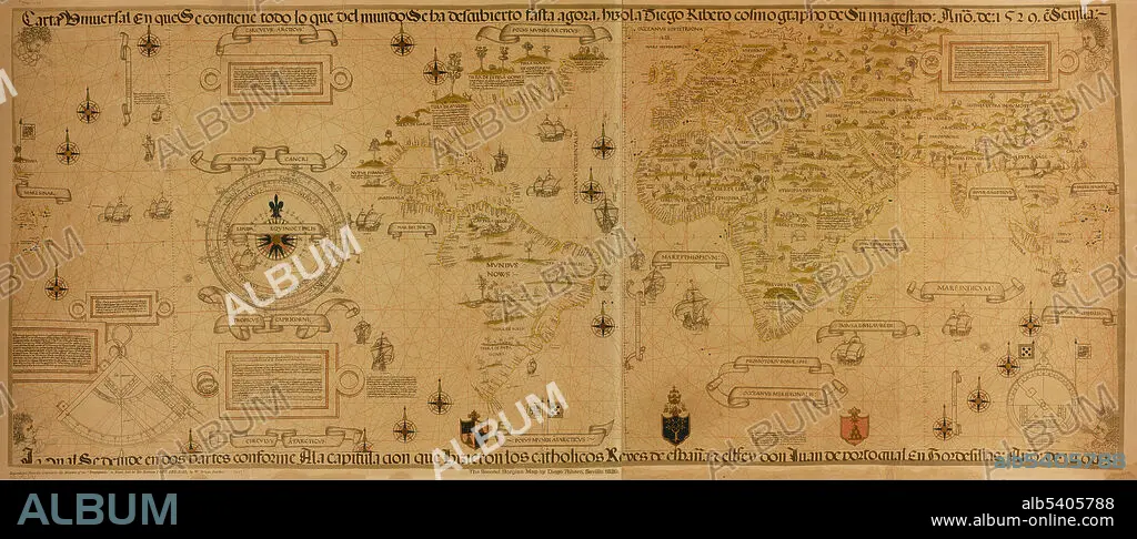
Carta universal en que se contiene todo lo que del mundo se ha descubierto fasta agora. The second Borgian map by Diego Ribero, Seville 1529. Reproduced from the original in the Museum of the Propaganda in Rome, lent by His Holiness Pope Leo XIII, by W. Griggs, London. Diogo Ribeiro, also known as Diego Ribero, was a Portuguese cartographer and explorer. He worked on the official maps of the Padrón Real (or Padrón General) from 1518-1532. The layout of the map (Mapamundi) is strongly influenced by the information obtained during the Magellan-Elcano trip around the world. Diogo's map delineates very precisely the coasts of Central and South America. It shows the whole east coast of the Americas but of the west coast only the area from Guatemala to Ecuador. However, neither Australia nor Antarctica appear, and the Indian subcontinent appears too small. The map shows, for the first time, the real extension of the Pacific Ocean. It also shows, for the first time, the North American coast as a continuous one. The absence of any large continent south of Asia is evidence that there had been no discovery of Australia at that date.
Carta universal en que se contiene todo lo que del mundo se ha descubierto fasta agora. The second Borgian map by Diego Ribero, Seville 1529. Reproduced from the original in the Museum of the Propaganda in Rome, lent by His Holiness Pope Leo XIII, by W. Griggs, London. Diogo Ribeiro, also known as Diego Ribero, was a Portuguese cartographer and explorer. He worked on the official maps of the Padrón Real (or Padrón General) from 1518-1532. The layout of the map (Mapamundi) is strongly influenced by the information obtained during the Magellan-Elcano trip around the world. Diogo's map delineates very precisely the coasts of Central and South America. It shows the whole east coast of the Americas but of the west coast only the area from Guatemala to Ecuador. However, neither Australia nor Antarctica appear, and the Indian subcontinent appears too small. The map shows, for the first time, the real extension of the Pacific Ocean. It also shows, for the first time, the North American coast as a continuous one. The absence of any large continent south of Asia is evidence that there had been no discovery of Australia at that date.
Crédit: Album / Science Source / LOC/Geography and Map Division
Autorisations: ? Autorisation de modèle: Non - ? Autorisation de propriété: Non
Questions sur les droits?
Questions sur les droits?
Taille de l'image: 5700 × 2409 px | 39.3 MB
Taille d'impression: 48.3 × 20.4 cm | 2244.1 × 948.4 in (300 dpi)
Mots clés: 16E SIECLE • 16EME S • CARTE • CARTOGRAPHIE • CÉLÈBRE • CELEBRITE • GEOGRAPHIE • MAPPEMONDE • NAVIGATION • PLANISPHERE • SCIENCE: CARTOGRAPHIE • SEIZIÈME SIÈCLE • XVIE SIECLE
