alb1647120
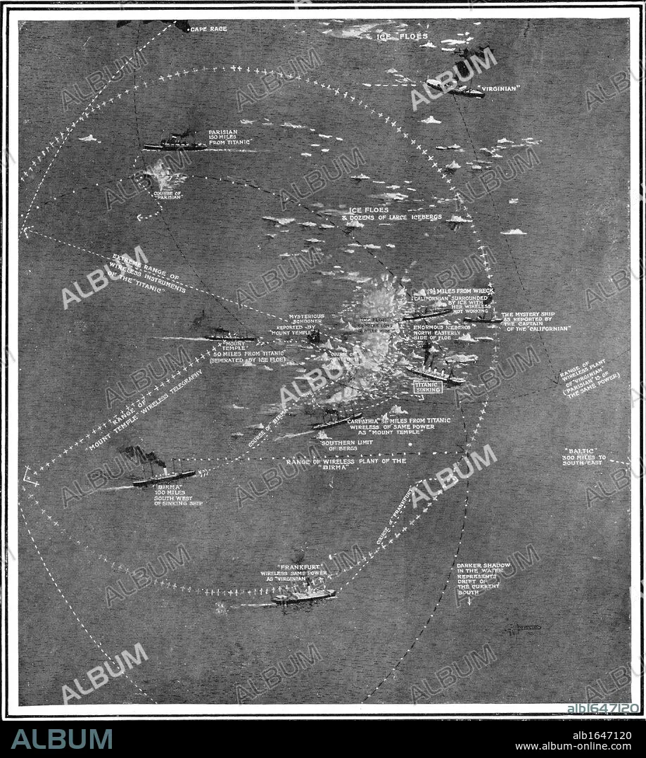
Chart of the RMS Titanic wreck site showing ships within call by wireless at the time of the collision.
| Partager |
|---|
 Pinterest Pinterest |
 Twitter Twitter |
 Facebook Facebook |
 Copier le lien Copier le lien |
 Email Email |
|
Ajouter à une autre Lightbox |
|
Ajouter à une autre Lightbox |


Avez-vous déjà un compte? S'identifier
Vous n'avez pas de compte ? S'inscrire
Acheter cette image

Légende:
Voir la traduction automatique
Chart of the RMS Titanic wreck site showing ships within call by wireless at the time of the collision
Crédit:
Album / Universal Images Group / Universal History Archive
Autorisations:
Modèle: Non - Propriété: Non
Questions sur les droits?
Questions sur les droits?
Taille de l'image:
4129 x 4606 px | 54.4 MB
Taille d'impression:
35.0 x 39.0 cm | 13.8 x 15.4 in (300 dpi)
Mots clés:
ANGALIS • ANGLAIS • ANGLAISE • APPARTEMENT SOUS LES TOITS • ART, PHOTOGRAPHIE • ASTRE • BATEAU EPAVE • BLANC • BLANCHE • CALAMITE • CARTE (GEOGRAPHIE) • CARTE GEOGRAPHIQUE • CARTE • CATASTROPHE • COLLISION • COMMUNICATION RADIO • DESASTRE • DESASTRES • DESSIN PLANS • DETRESSE EN MER • ÉPAVES • ETOILE • GRAND MALHEUR • ICEBERG • INSTANTANE (PHOTO) • INSTANTANÉ • INSTRUMENT RADIO • KEN • LIGNE • MALCHANCE • MALHEUR • MER • MER, NAUFRAGE • NAUFRAGE • NOIR ET BLANC • OCEAN • PAYSAGE MARITIME • PHOTOGRAPHIE • PLAN (CARTOGRAPHIE) • PLANS • RADIO • RADIOS • RESISTANCE 2E G. M.: RADIO • SNAPSHOT
