alb1540462
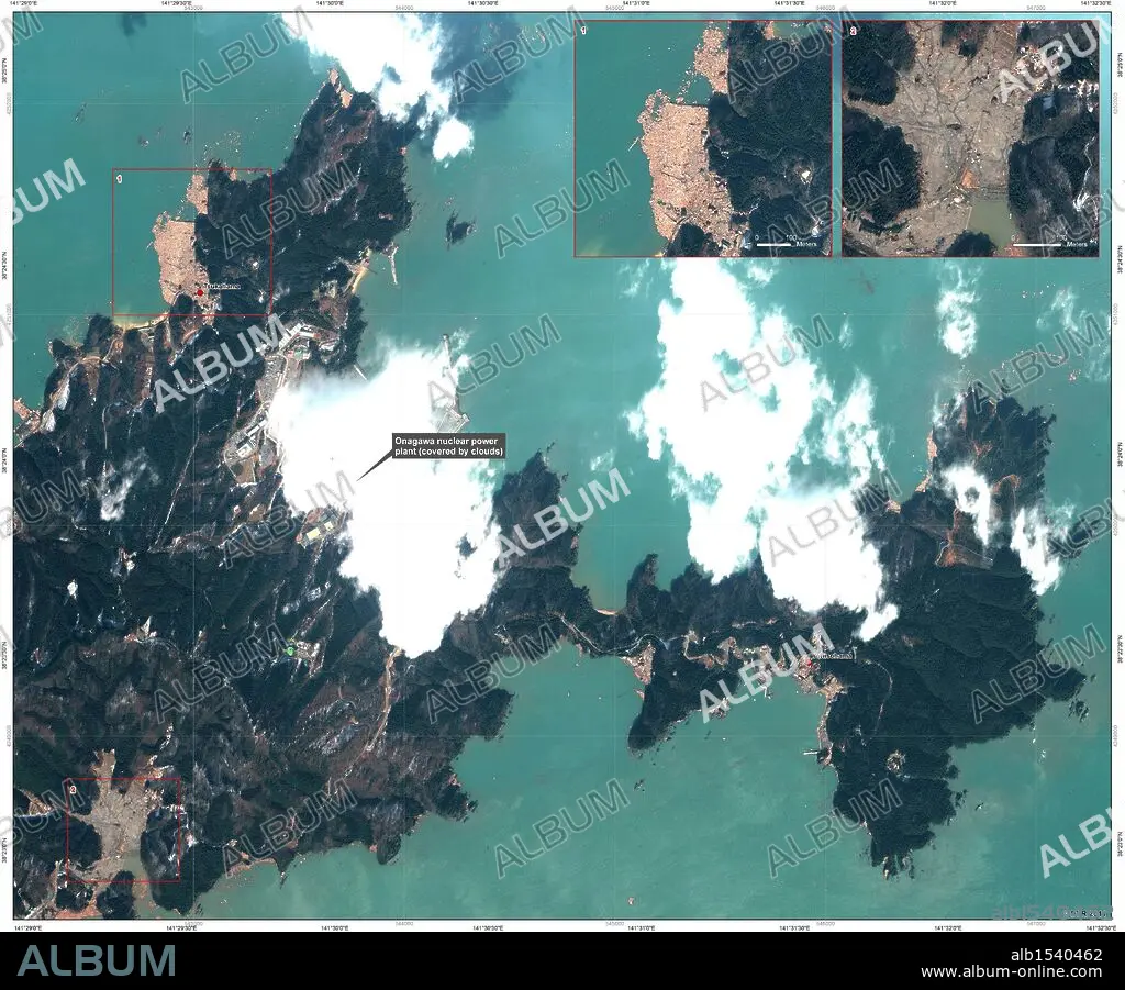
Mar. 13, 2011 - Momonoura, Oshika Peninsula, Japan - A 9.0 magnitude earthquake and resuting tsunami devastated the northeastern region of Japan on Friday, March 11, 2011. These maps and satellite images by the German Aerospace Center (Deutsches Luft- und Raumfahrtzentrum, DLR) provide an overview of the destruction and compares images of the affected areas before and after the disaster. PICTURED: Disaster Extent Map Detail - Japan, Oshika Peninsula - Sheet 4: Onagawa Nuclear Power Plant - Earthquake/Tsunami. March 13, 2011, 16:53 CET - last update on March 13, 2011, 22:47 CET; Map type: Satellite Map; Scale: 1:7,500. Interpretation: The map shows an overview of the Oshika Peninsula in the east of Sendai which was strongly affected by the earthquake/tsunami. (Credit Image: © German Aerospace Center (DLR)/ZUMAPRESS.com). 13/03/2011
| Partager |
|---|
 Pinterest Pinterest |
 Twitter Twitter |
 Facebook Facebook |
 Copier le lien Copier le lien |
 Email Email |
|
Ajouter à une autre Lightbox |
|
Ajouter à une autre Lightbox |


Avez-vous déjà un compte? S'identifier
Vous n'avez pas de compte ? S'inscrire
Acheter cette image.
Sélectionnez l'usage:

Légende: Voir la traduction automatique
Mar. 13, 2011 - Momonoura, Oshika Peninsula, Japan - A 9.0 magnitude earthquake and resuting tsunami devastated the northeastern region of Japan on Friday, March 11, 2011. These maps and satellite images by the German Aerospace Center (Deutsches Luft- und Raumfahrtzentrum, DLR) provide an overview of the destruction and compares images of the affected areas before and after the disaster. PICTURED: Disaster Extent Map Detail - Japan, Oshika Peninsula - Sheet 4: Onagawa Nuclear Power Plant - Earthquake/Tsunami. March 13, 2011, 16:53 CET - last update on March 13, 2011, 22:47 CET; Map type: Satellite Map; Scale: 1:7,500. Interpretation: The map shows an overview of the Oshika Peninsula in the east of Sendai which was strongly affected by the earthquake/tsunami. (Credit Image: © German Aerospace Center (DLR)/ZUMAPRESS.com)
Mar. 13, 2011 - Momonoura, Oshika Peninsula, Japan - A 9.0 magnitude earthquake and resuting tsunami devastated the northeastern region of Japan on Friday, March 11, 2011. These maps and satellite images by the German Aerospace Center (Deutsches Luft- und Raumfahrtzentrum, DLR) provide an overview of the destruction and compares images of the affected areas before and after the disaster. PICTURED: Disaster Extent Map Detail - Japan, Oshika Peninsula - Sheet 4: Onagawa Nuclear Power Plant - Earthquake/Tsunami. March 13, 2011, 16:53 CET - last update on March 13, 2011, 22:47 CET; Map type: Satellite Map; Scale: 1:7,500. Interpretation: The map shows an overview of the Oshika Peninsula in the east of Sendai which was strongly affected by the earthquake/tsunami. (Credit Image: © German Aerospace Center (DLR)/ZUMAPRESS.com)
Crédit: Album / KPA-ZUMA
Autorisations: ? Autorisation de modèle: Non - ? Autorisation de propriété: Non
Questions sur les droits?
Questions sur les droits?
Taille de l'image: 4600 × 3808 px | 50.1 MB
Taille d'impression: 38.9 × 32.2 cm | 1811.0 × 1499.2 in (300 dpi)
Mots clés: CALAMITE • CATASTROPHE • DESASTRE • DESASTRES • GRAND MALHEUR • JAPON • JAPONAIS • MALCHANCE • MALHEUR • ORNEMENT, JAPONAIS • SEISME • TREMBLEMENT DE TERRE • VUE AERIENNE
