alb4058820
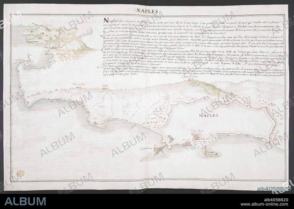
Bird's-eye view of the coastline between Naples and Pozzuoli, with details of the city walls, lighthouse, moles, arsenal and fortifications of Naples in the foreground including the Castel Nuovo, Castel St Elmo and the Castel dell'Ovo, and Chiaia, Posillipo and Pozzuoli in the background; explanatory text above. Extensively inscribed in brown ink on verso with number '170' and text entitled 'NAPLES / Haures qui sont dans le Royaume de Naples'. 'A colored plan of the fortifications of Naples, with the adjacent coast; drawn by a French artist, about 1650, accompanied with a description, and a short account of the harbours in the kingdom of Naples'. Naples. about 1650. 1 drawing : brown ink and watercolour ; sheet 48 x 73 cm. Source: Maps K.Top.83.54.
| Partager |
|---|
 Pinterest Pinterest |
 Twitter Twitter |
 Facebook Facebook |
 Copier le lien Copier le lien |
 Email Email |
|
Ajouter à une autre Lightbox |
|
Ajouter à une autre Lightbox |


Avez-vous déjà un compte? S'identifier
Vous n'avez pas de compte ? S'inscrire
Acheter cette image

Légende:
Voir la traduction automatique
Bird's-eye view of the coastline between Naples and Pozzuoli, with details of the city walls, lighthouse, moles, arsenal and fortifications of Naples in the foreground including the Castel Nuovo, Castel St Elmo and the Castel dell'Ovo, and Chiaia, Posillipo and Pozzuoli in the background; explanatory text above. Extensively inscribed in brown ink on verso with number '170' and text entitled 'NAPLES / Haures qui sont dans le Royaume de Naples'. 'A colored plan of the fortifications of Naples, with the adjacent coast; drawn by a French artist, about 1650, accompanied with a description, and a short account of the harbours in the kingdom of Naples'. Naples. about 1650. 1 drawing : brown ink and watercolour ; sheet 48 x 73 cm. Source: Maps K.Top.83.54.
Crédit:
Album / British Library
Autorisations:
Modèle: Non - Propriété: Non
Questions sur les droits?
Questions sur les droits?
Taille de l'image:
8864 x 5850 px | 148.4 MB
Taille d'impression:
75.0 x 49.5 cm | 29.5 x 19.5 in (300 dpi)
Mots clés:
17E SIECLE • 17EME S • CÔTE • DIX-SEPTIÈME SIÈCLE • EUROPE • ITALIE • LITTORAL • MARITIME • NAPLES • PAYSAGE MARITIME AV. PLAGE • XVIIE SIECLE
