alb4198670
City of Toronto: compiled from surveys 1873
| Partager |
|---|
 Pinterest Pinterest |
 Twitter Twitter |
 Facebook Facebook |
 Copier le lien Copier le lien |
 Email Email |
|
Ajouter à une autre Lightbox |
|
Ajouter à une autre Lightbox |


Avez-vous déjà un compte? S'identifier
Vous n'avez pas de compte ? S'inscrire
Acheter cette image.
Sélectionnez l'usage:

Titre:
City of Toronto: compiled from surveys 1873
Légende:
Voir la traduction automatique
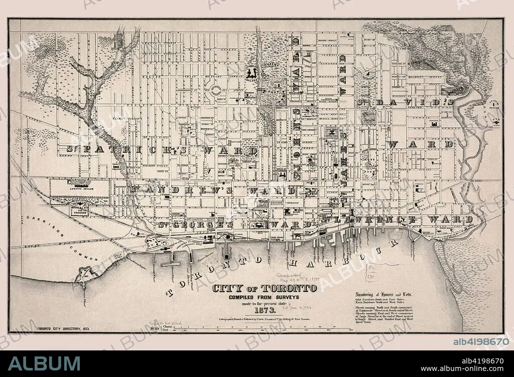
Toronto, Canada's largest urban center and the capital of Ontario Province, was founded in 1791 by British Loyalists. Originally named York, the settlement was renamed Toronto in 1834 with the granting of a city charter. The city's rectangular grid pattern of streets, which was used for most United States and Canadian cities laid out in the 19th century, is depicted on this 1873 map which was published to accompany a city directory. Representative of late 19th-century urban maps, it shows the individual streets and street names, as well as the city's wards, public parks, and prominent buildings including the parliament buildings, colleges, schools, hospitals, churches, and asylums. Particularly evident are the railroads, which feed into the central business district and terminate at a number of wharves protruding into the harbor, providing evidence of the city's commercial and transportation functions. - Copp Clark Company
Crédit:
Album / Universal Images Group / Universal History Archive/UIG
Autorisations:
Taille de l'image:
8620 x 5882 px | 145.1 MB
Taille d'impression:
73.0 x 49.8 cm | 28.7 x 19.6 in (300 dpi)
Mots clés:
ARRONDISSEMENT • BANLIEUE • CANADA • CAPITALE • CARTE (GEOGRAPHIE) • CARTE GEOGRAPHIQUE • CARTE • CITE • CLINIQUE • DESSIN PLANS • ECCLESIA • EGLISE • EGLISE, INTERIEUR • ÉGLISES • ESPACE VERT • FAUBOURG • HOPITAL • HÔPITAUX • INTERIEUR: EGLISE • JARDINS • MANAGER • MEDECINE HOPITAL • METROPOLE • PARC • PARCS • PLAN (CARTOGRAPHIE) • PLANS • PROVINCE • PROVINS • QUARTIER • RUE • VILE • VILLE • XIXE SIÈCLE
