alb5392035
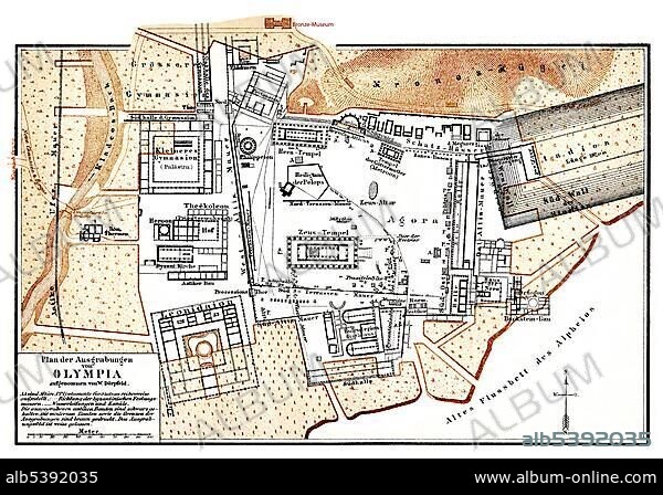
Historic map of the excavations at Olympia, Greece, 19th Century, from Meyers Konversations-Lexikon encyclopaedia, 1889, Europe.
| Partager |
|---|
 Pinterest Pinterest |
 Twitter Twitter |
 Facebook Facebook |
 Copier le lien Copier le lien |
 Email Email |
|
Ajouter à une autre Lightbox |
|
Ajouter à une autre Lightbox |


Avez-vous déjà un compte? S'identifier
Vous n'avez pas de compte ? S'inscrire
Acheter cette image

Légende:
Voir la traduction automatique
Historic map of the excavations at Olympia, Greece, 19th Century, from Meyers Konversations-Lexikon encyclopaedia, 1889, Europe
Personnalités:
Crédit:
Album / ImageBroker / H.-D. Falkenstein
Autorisations:
Modèle: Non - Propriété: Non
Questions sur les droits?
Questions sur les droits?
Taille de l'image:
600 x 415 px | 729.5 KB
Taille d'impression:
5.1 x 3.5 cm | 2.0 x 1.4 in (300 dpi)
Mots clés:
CADRE • CARTE • CARTES • CARTON • GEOGRAPHIE • GRECE • IMAGES • INTERIEUR: TABLEAUX • PEINDRE • PEINTURE, SCENES D'INTERIE • PLAN • SITE ARCHEOLOGIQUE • SITE • TABLEAU: SCENES D'INTERIEU • TABLEAUX • TRAVAUX DE TERRASSEMENT
