alb3792485
Amazon River, Manaus, Brazil
| Partager |
|---|
 Pinterest Pinterest |
 Twitter Twitter |
 Facebook Facebook |
 Copier le lien Copier le lien |
 Email Email |
|
Ajouter à une autre Lightbox |
|
Ajouter à une autre Lightbox |


Avez-vous déjà un compte? S'identifier
Vous n'avez pas de compte ? S'inscrire
Acheter cette image.
Sélectionnez l'usage:

Titre: Amazon River, Manaus, Brazil
Légende: Voir la traduction automatique
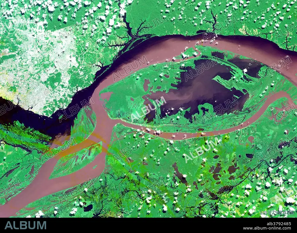
Satellite image of the junctions of the Amazon and the Rio Negro Rivers at Manaus, Brazil. The Rio Negro flows 2300 km from Columbia, and is the dark current forming the north side of the river. It gets its color from the high tannin content in the water. The Amazon is sediment laden, appearing brown in this simulated natural color image. Manaus is the capital of Amazonas state, and has a population in excess of one million. This image covers an area of 60 x 45 km and was acquired on July 16, 2000 by the Advanced Spaceborne Thermal Emission and Reflection Radiometer (ASTER) on NASA's Terra satellite.
Satellite image of the junctions of the Amazon and the Rio Negro Rivers at Manaus, Brazil. The Rio Negro flows 2300 km from Columbia, and is the dark current forming the north side of the river. It gets its color from the high tannin content in the water. The Amazon is sediment laden, appearing brown in this simulated natural color image. Manaus is the capital of Amazonas state, and has a population in excess of one million. This image covers an area of 60 x 45 km and was acquired on July 16, 2000 by the Advanced Spaceborne Thermal Emission and Reflection Radiometer (ASTER) on NASA's Terra satellite.
Crédit: Album / Science Source / NASA/GSFC/METI/ERSDAC/JAROS, and U.S./Japan ASTER Science Team
Autorisations: ? Autorisation de modèle: Non - ? Autorisation de propriété: Non
Questions sur les droits?
Questions sur les droits?
Taille de l'image: 3885 × 2852 px | 31.7 MB
Taille d'impression: 32.9 × 24.1 cm | 1529.5 × 1122.8 in (300 dpi)
Mots clés: AÉRIEN • AMERIQUE LATINE (AMERIQUE DU SUD) • AMERIQUE LATINE • BRÉSIL • CARREFOUR • GEOGRAPHIE • TOPOGRAPHIE
