alb3814404
Mississippi Flood, 1915
| Partager |
|---|
 Pinterest Pinterest |
 Twitter Twitter |
 Facebook Facebook |
 Copier le lien Copier le lien |
 Email Email |
|
Ajouter à une autre Lightbox |
|
Ajouter à une autre Lightbox |


Avez-vous déjà un compte? S'identifier
Vous n'avez pas de compte ? S'inscrire
Acheter cette image.
Sélectionnez l'usage:

Titre: Mississippi Flood, 1915
Légende: Voir la traduction automatique
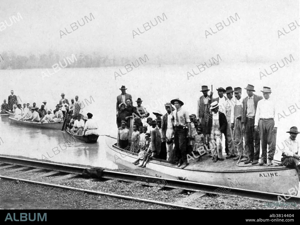
The Mississippi River is the chief river of the largest river system in North America. The Mississippi ranks as the fourth longest and tenth largest river in the world. The river either borders or cuts through the states of Minnesota, Wisconsin, Iowa, Illinois, Missouri, Kentucky, Tennessee, Arkansas, Mississippi, and Louisiana. The Mississippi drainage basin is the fifth largest in the world. Areal (rain related) flooding of the Mississippi occurs primarily in the southern states of Mississippi and Louisiana. Following the Great Flood of 1927, the Army Corps of Engineers was charged with taming the Mississippi River. Under the Flood Control Act of 1928, the world's longest system of levees was built. Floodways that diverted excessive flow from the Mississippi River were constructed. Photo originally captioned: "Refugees. Driven from their homes." In: "The Mississippi River Flood Problem," by John A. Fox, 1915.
The Mississippi River is the chief river of the largest river system in North America. The Mississippi ranks as the fourth longest and tenth largest river in the world. The river either borders or cuts through the states of Minnesota, Wisconsin, Iowa, Illinois, Missouri, Kentucky, Tennessee, Arkansas, Mississippi, and Louisiana. The Mississippi drainage basin is the fifth largest in the world. Areal (rain related) flooding of the Mississippi occurs primarily in the southern states of Mississippi and Louisiana. Following the Great Flood of 1927, the Army Corps of Engineers was charged with taming the Mississippi River. Under the Flood Control Act of 1928, the world's longest system of levees was built. Floodways that diverted excessive flow from the Mississippi River were constructed. Photo originally captioned: "Refugees. Driven from their homes." In: "The Mississippi River Flood Problem," by John A. Fox, 1915.
Catégorie: TEMPS (METEOROLOGIE)
Crédit: Album / NOAA/Science Source
Autorisations: ? Autorisation de modèle: Non - ? Autorisation de propriété: Non
Questions sur les droits?
Questions sur les droits?
Taille de l'image: 5100 × 3551 px | 51.8 MB
Taille d'impression: 43.2 × 30.1 cm | 2007.9 × 1398.0 in (300 dpi)
Mots clés: AMÉRICAIN • CÉLÈBRE • CELEBRITE • CLOCHARD • DEGAT DE TEMPETE • DEGAT DES EAUX • DEGAT • DESTRCUTION • DESTRUCTION • DESTRUCUTION • DETERIORATION • DEVASTATION • ENDOMMAGEMENT • ÉVÉNEMENT • INONDATION • METEOROLOGIE • REFUGIES • SANS-ABRI • TEMPS (METEOROLOGIE) • VAGABOND • VIOLENT • XXE SIECLE
