alb3838807
Tropical Cyclone Sidr
| Partager |
|---|
 Pinterest Pinterest |
 Twitter Twitter |
 Facebook Facebook |
 Copier le lien Copier le lien |
 Email Email |
|
Ajouter à une autre Lightbox |
|
Ajouter à une autre Lightbox |


Avez-vous déjà un compte? S'identifier
Vous n'avez pas de compte ? S'inscrire
Acheter cette image.
Sélectionnez l'usage:

Titre: Tropical Cyclone Sidr
Légende: Voir la traduction automatique
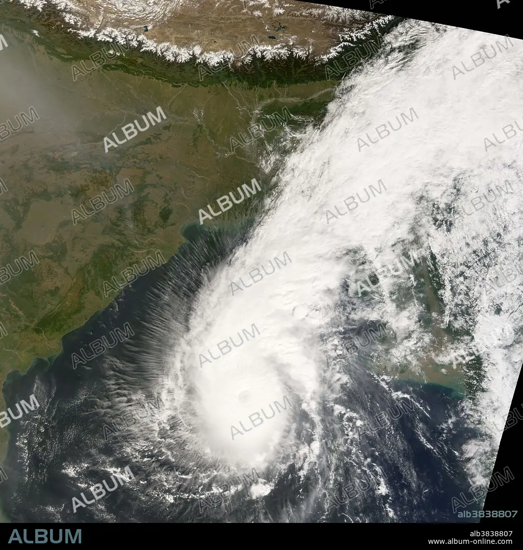
Tropical Cyclone Sidr was continuing its northward progress over the Bay of Bengal on November 14, 2007. It was moving north toward the Mouths of the Ganges at a speed of 13 kilometers per hour (8 miles per hour), and winds in the storm system were raging at 220 km/hr (140 mph) near the storm's center, making it a Category 4 strength tropical cyclone. The Moderate Resolution Imaging Spectroradiometer (MODIS) on NASA's Terra satellite acquired this photo-like image at 10:15 a.m. local time (4:45 UTC) on November 14, 2007. Tropical Cyclone Sidr appears here as a well-developed and distinct ball of circling clouds; the storm has a distinct but cloudy eye at its center. An extended arm of clouds reaches northward from the storm across Bangladesh, bringing the influence of the storm onshore already even though it was hundreds of kilometers to the south. Western Bangladesh, where the storm appeared to be headed as of November 15, is the most heavily populated low-lying area in the world, with a history of severe causalities from previous storms due to both direct flooding and storm surge. The Joint Typhoon Warning Center was predicting that the storm would weaken, but still make landfall with hurricane-force winds. In 1970, a Category 3 storm that made landfall in the same vicinity caused 300,000 deaths and was one of the most deadly natural disasters in modern history. Another 138,000 people perished in 1991 from another such cyclone.
Tropical Cyclone Sidr was continuing its northward progress over the Bay of Bengal on November 14, 2007. It was moving north toward the Mouths of the Ganges at a speed of 13 kilometers per hour (8 miles per hour), and winds in the storm system were raging at 220 km/hr (140 mph) near the storm's center, making it a Category 4 strength tropical cyclone. The Moderate Resolution Imaging Spectroradiometer (MODIS) on NASA's Terra satellite acquired this photo-like image at 10:15 a.m. local time (4:45 UTC) on November 14, 2007. Tropical Cyclone Sidr appears here as a well-developed and distinct ball of circling clouds; the storm has a distinct but cloudy eye at its center. An extended arm of clouds reaches northward from the storm across Bangladesh, bringing the influence of the storm onshore already even though it was hundreds of kilometers to the south. Western Bangladesh, where the storm appeared to be headed as of November 15, is the most heavily populated low-lying area in the world, with a history of severe causalities from previous storms due to both direct flooding and storm surge. The Joint Typhoon Warning Center was predicting that the storm would weaken, but still make landfall with hurricane-force winds. In 1970, a Category 3 storm that made landfall in the same vicinity caused 300,000 deaths and was one of the most deadly natural disasters in modern history. Another 138,000 people perished in 1991 from another such cyclone.
Crédit: Album / Science Source / NASA
Autorisations: ? Autorisation de modèle: Non - ? Autorisation de propriété: Non
Questions sur les droits?
Questions sur les droits?
Taille de l'image: 8896 × 8896 px | 226.4 MB
Taille d'impression: 75.3 × 75.3 cm | 3502.4 × 3502.4 in (300 dpi)
Mots clés: SATELLITE
