alb1963444
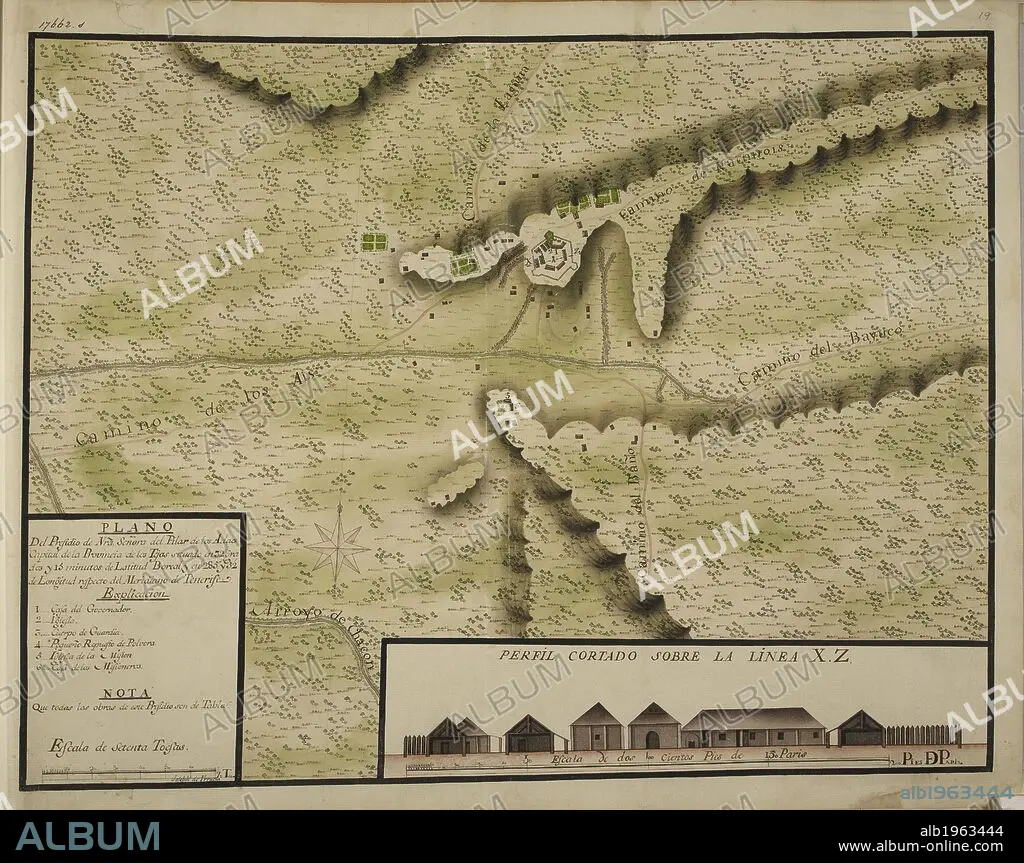
"Plano del Presidio de Nuestra Señora del Pilar de los Adaes, capital de la provincia de los Tejas, situado en 32º y 15ʹ de latitud boreal;" drawn by Joseph de Vrrutia, on a scale of 48 toises to an inch; with a profile on a scale of 18 Paris feet to an inch. . TWENTY-ONE coloured maps and plans of towns and various settlements in the North of Mexico with their environs; all, except one, situated in the Provincias Internas. By Joseph de Urrutia. Paper, XVIIIth cent. Folio. Ca. 1768. Source: Add. 17662 s19.
| Partager |
|---|
 Pinterest Pinterest |
 Twitter Twitter |
 Facebook Facebook |
 Copier le lien Copier le lien |
 Email Email |
|
Ajouter à une autre Lightbox |
|
Ajouter à une autre Lightbox |


Avez-vous déjà un compte? S'identifier
Vous n'avez pas de compte ? S'inscrire
Acheter cette image

Auteur:
Légende:
Voir la traduction automatique
"Plano del Presidio de Nuestra Señora del Pilar de los Adaes, capital de la provincia de los Tejas, situado en 32º y 15ʹ de latitud boreal;" drawn by Joseph de Vrrutia, on a scale of 48 toises to an inch; with a profile on a scale of 18 Paris feet to an inch. . TWENTY-ONE coloured maps and plans of towns and various settlements in the North of Mexico with their environs; all, except one, situated in the Provincias Internas. By Joseph de Urrutia. Paper, XVIIIth cent. Folio. Ca. 1768. Source: Add. 17662 s19.
Crédit:
Album / British Library
Autorisations:
Modèle: Non - Propriété: Non
Questions sur les droits?
Questions sur les droits?
Taille de l'image:
6410 x 5068 px | 92.9 MB
Taille d'impression:
54.3 x 42.9 cm | 21.4 x 16.9 in (300 dpi)
Mots clés:
18 18E 18EME XVIII XVIIIE XVIIIEME SIECLE • 18E SIECLE • 18EME S • AMERICAIN (ETATS-UNIS) • AMERICAIN (USA) • CARTE (GEOGRAPHIE) • CARTE GEOGRAPHIQUE • CARTE • CARTOGRAPHIE • DE URRUTIA, JOSEPH • DESSIN PLANS • DIX-HUITIÈME SIÈCLE • ÉTAS UNIS • ÉTAS-UNIS • ETATS UNIS • ETATS-UNIS • MEXICO • MEXIQUE • PLAN (CARTOGRAPHIE) • PLANS • SCIENCE: CARTOGRAPHIE • U. S. A. • XVIIIE SIECLE • ŽTATS-UNIS
