alb9451594
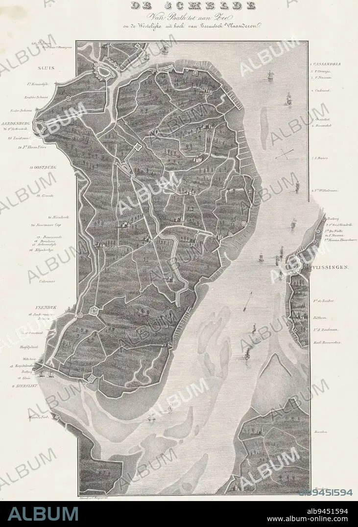
Map of the course of the Scheldt from Koudorp (bottom) to Sluis (top), at the time of the siege of Antwerp in December 1832. Along the river the various entrenchments and forts are indicated. The legend on either side of the representation 1-28. Map in two sheets, of which this is the upper part, Loop van de Schelde van Fort Bath tot zee (upper sheet), 1832 De Schelde Van Bath tot aan Zee. en de Westelijke uit hoek van Zeeuwsch Vlaanderen (title on object), print maker: Willem Charles Magnenat, (mentioned on object), publisher: Frans Buffa en Zonen, (mentioned on object), print maker: Netherlands, publisher: Amsterdam, 1833, paper, h 543 mm × w 380 mm.
| Partager |
|---|
 Pinterest Pinterest |
 Twitter Twitter |
 Facebook Facebook |
 Copier le lien Copier le lien |
 Email Email |
|
Ajouter à une autre Lightbox |
|
Ajouter à une autre Lightbox |


Avez-vous déjà un compte? S'identifier
Vous n'avez pas de compte ? S'inscrire
Acheter cette image.
Sélectionnez l'usage:

Légende: Voir la traduction automatique
Map of the course of the Scheldt from Koudorp (bottom) to Sluis (top), at the time of the siege of Antwerp in December 1832. Along the river the various entrenchments and forts are indicated. The legend on either side of the representation 1-28. Map in two sheets, of which this is the upper part, Loop van de Schelde van Fort Bath tot zee (upper sheet), 1832 De Schelde Van Bath tot aan Zee. en de Westelijke uit hoek van Zeeuwsch Vlaanderen (title on object), print maker: Willem Charles Magnenat, (mentioned on object), publisher: Frans Buffa en Zonen, (mentioned on object), print maker: Netherlands, publisher: Amsterdam, 1833, paper, h 543 mm × w 380 mm
Map of the course of the Scheldt from Koudorp (bottom) to Sluis (top), at the time of the siege of Antwerp in December 1832. Along the river the various entrenchments and forts are indicated. The legend on either side of the representation 1-28. Map in two sheets, of which this is the upper part, Loop van de Schelde van Fort Bath tot zee (upper sheet), 1832 De Schelde Van Bath tot aan Zee. en de Westelijke uit hoek van Zeeuwsch Vlaanderen (title on object), print maker: Willem Charles Magnenat, (mentioned on object), publisher: Frans Buffa en Zonen, (mentioned on object), print maker: Netherlands, publisher: Amsterdam, 1833, paper, h 543 mm × w 380 mm
Crédit: Album / quintlox
Autorisations: ? Autorisation de modèle: Non - ? Autorisation de propriété: Non
Questions sur les droits?
Questions sur les droits?
Taille de l'image: 3690 × 5167 px | 54.5 MB
Taille d'impression: 31.2 × 43.7 cm | 1452.8 × 2034.3 in (300 dpi)
Mots clés: AMSTERDAM • ANVERS • CARTE (GEOGRAPHIE) • CARTE GEOGRAPHIQUE • CARTE • DESSIN PLANS • FLUVIALE • OBJET • PAPIER • PLAN (CARTOGRAPHIE) • PLANS • TEMPS
