alb4056454
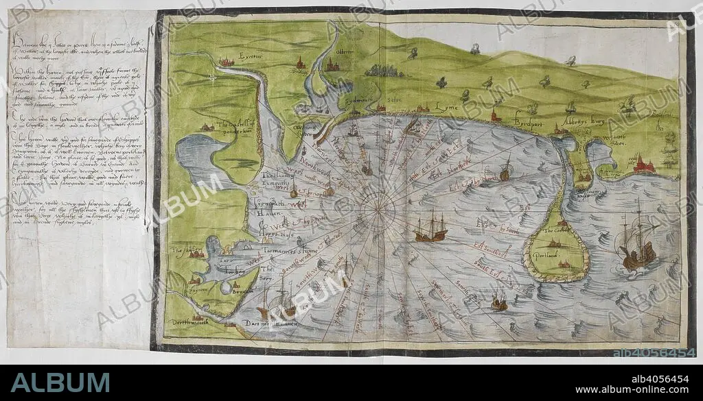
CHRISTOPHER SAXTON. Coloured manuscript map of the south coast of Devon and Dorset, from Dartmouth to Weymouth, with a description of Ottermouth Haven. Lord Burghley's Atlas. London; 1579. SAXTON, SAXTON's. Source: Royal 18 D. III, ff.9v-10. Language: English.
| Partager |
|---|
 Pinterest Pinterest |
 Twitter Twitter |
 Facebook Facebook |
 Copier le lien Copier le lien |
 Email Email |
|
Ajouter à une autre Lightbox |
|
Ajouter à une autre Lightbox |


Avez-vous déjà un compte? S'identifier
Vous n'avez pas de compte ? S'inscrire
Acheter cette image

Légende:
Voir la traduction automatique
Coloured manuscript map of the south coast of Devon and Dorset, from Dartmouth to Weymouth, with a description of Ottermouth Haven. Lord Burghley's Atlas. London; 1579. SAXTON, SAXTON's. Source: Royal 18 D. III, ff.9v-10. Language: English.
Crédit:
Album / British Library
Autorisations:
Modèle: Non - Propriété: Non
Questions sur les droits?
Questions sur les droits?
Taille de l'image:
7033 x 3654 px | 73.5 MB
Taille d'impression:
59.5 x 30.9 cm | 23.4 x 12.2 in (300 dpi)
Mots clés:
16E SIECLE • 16EME S • ANGLETARRE • ANGLETERE • ANGLETERRE • CARTE (GEOGRAPHIE) • CARTE GEOGRAPHIQUE • CARTE • CARTOGRAPHIE • DESSIN PLANS • DEVON • GRANDE BERTAGNE • GRANDE BRETAGNE • GRANDE-BRETAGNE • INGLATERRA • PLAN (CARTOGRAPHIE) • PLANS • ROYAUME UNI • ROYAUME-UNI • SAXTON, CHRISTOPHER • SCIENCE: CARTOGRAPHIE • SEIZIÈME SIÈCLE • XVIE SIECLE
